Romance in Murals – Expression of Love at Chitrasala in Bundi

‘That slender one should send a letter

Couched in artistic language

Written on a Kettaki leaf, scratched by Kasturi and wrapped by a silken thread

Having a symbol of her breasts smeared with sandal paste

With her name inscribed on upper portion’

IMG_7897


‘Forgetful of worldly attachments

Lost in his thoughts

Suffering from fever caused by his memory

She heaves deep sighs, neglects her food, walks or rest

Without bothering to listen to her friends’

IMG_7907


‘High palaces and blossoming lotuses

Do not give the pleasure any more

She throws the ornaments being placed on her body by her friends

Nor is she delighted by acts of entertainment

Having achieved an objective she is restless

Is desirous of engaging in such pursuits

Which she could not in the presence of her lover’

IMG_7775

The 18th-century Chitrasala of Bundi palace in Southeastern Rajasthan is a chock-a-block of romantic depictions of Shringar Rasa in the form of large murals. Most of Chitrasala murals are inspired by Rasikapriya, a love poem written by Keshavdash of the 16th century.

IMG_7896

Bundi takes its name from a narrow valley Bandu – Ka – Nal (Bandu was a chieftain of the Meena Tribe and Nal means the narrow ways). Rao Deva conquered this terrain in 1342 CE and renamed as Hadoti. The Aravali Mountains surrounding Bundi present the most picturesque view with its flowing rivers and lush green forest, in the whole of Rajasthan.

Also, Read Here:

BUNDI PAINTINGS FROM AN ARTIST’S PERSPECTIVE

IMG_8361

IMG_8363

IMG_8295

IMG_8195

IMG_8177

IMG_7621

Rasikapriya is portrayed as the vehicle of emotion. The description of the countryside, cities, forests, hermitages, rivers, gardens, tanks, sunrise, moonrise and the seasons are beautifully illustrated by the artists of Chitrasala. There are seven colours, namely, white, black, yellow, red, grey, blue and mixed tones that have been primarily used in Chitrasala murals.

Also, Read Here:

BUNDI FORT – A CONFLUENCE OF IDEAS

IMG_7752

IMG_7715

Keshavadeva defines a nayaka or hero as a man who is young, expert in the art of love, emotional, proud, selfless, generous, handsome, rich and reframed in taste and culture. A nayika is a heroine whose very sight fills a male’s heart with shringar rasa. There are four categories of naikyas according to Rasikapriya.

IMG_7820

IMG_7840

IMG_7822

IMG_7809

Padmini – Padmini is a beautiful nayika, soft as lotus, intelligent, cheerful, clean and soft-skinned, free from anger and has a golden complexion. She loves clean and beautiful cloths.

Travel Tips

Bundi is located in southeastern Rajasthan at a distance of 50 km from Kota, the largest city of the region. Bundi can be reached from Kota by regular bus services and shared vehicles. While at Bundi one can also explore the surrounding hill terrains rich in prehistoric rock art. There are many stay options in Bundi ranging from budget homestays to high end. Keep three days for your Bundi trip if you love a more relaxed slow trip.

IMG_7754

IMG_7755

IMG_7756

Chitrani – Chitrani is adorned with diverse beauties. She is fond of dancing and singing. She is fond of perfumes and her lover’s portraits.

Sankini – Sankini means short-tempered and clever. She is a luxuriant growth of hair, likes red garments and pinches hard when excited. She is shameless and unhesitant.

Hastini – She has a thick figure, a fat face and large feet. Her lower lip and eyebrows are thick and her voice is rough.

Another draw of Chitrasala is the Ragini murals. Ragas are primary sources of all musical renderings in India. Each Raga or Ragini has an emotional situation based on different facets of love, either in union or separation. Ragas are ascribed to Shiva and his consort Parvati and Raginis are ascribed to Brahma and his consort Saraswati.

IMG_7855

IMG_7815

IMG_7806

IMG_7804

IMG_7803

IMG_7799

IMG_7766

IMG_7786

IMG_7760

IMG_7761_1

The important features of Ragini murals at Chitrasala are strong eyes, pointed chin, projected nose, round face, Jahangir style turban, narrow patka with geometrical designs, transparent chakadar jama, attractive black pompoms and shading under the armpits. Ragini Todi, Ragini Megha Mallar, and Ragini Asvari are important examples of this sect.

The depiction of zenana or women’s harem is yet the attraction of Chitrasala murals. Zenanas are large palaces built for women. These palaces are divided into different apartments allotted to the royal women or queens, less important ladies who hold various managerial positions and attendants. In these wings, only the kings and princes are allowed. Some common zenana scenes that appear in Chitarasala are princes playing chaupar, palace gardens, palace ponds, palace terraces, the celebration of Teez festival and women listening to music, feeding the fish and enjoying wine and smoking huqqua.

IMG_7823

IMG_7791

IMG_7790

IMG_7777

IMG_7764_1

IMG_7762 copy

The love murals of Chitrasala are a treat to eyes. They follow shringar at all its spell and intensity – when the passion strikes a woman after seeing her lover she sweats and is thrilled with romance and such is the intensity of her involvement she does not see even her friend standing nearby.  They integrate with the landscape of Bundi and the cycle of seasons. There are joy and delight everywhere.

Author – Jitu Mishra

He can be contacted at jitumisra@gmail.com

Dhenkanal – Wars, Wilderness and Royal Hospitality

Year 1781! While most of Western Europe was at the forefront of the industrial revolution, a part of Odisha was passing through a political turmoil.  Odisha would witness intense rivalry between princely states and with the Maratha Force.

IMG_0267

Dhenkanal, one of the flourishing princely states in Odisha located amidst the dense jungle of Gadajat Mountains was a key witness to the political unrest happening in the 18th century. An 18-day Maratha seize had been the highlight which is narrated distinctly in ‘Samar Tarang’, a war poem written by the contemporary writer Brajanath Badajena.

Travel Tips

Dhenkanal is a medium-sized city located at a distance of 80 km from Bhubaneswar. Both Dhenkanal (http://www.dhenkanalpalace.com/) and Gajalaxmi Palaces (http://gajlaxmipalace.com/) facilitate as heritage homestays and have become favourite destinations among overseas travellers. While there are 13 rooms available at Dhenkanal Palace, the Gajalaxmi Palace has six rooms for guests. While at Dhenkanal do visit the Dokra village at Sadeiberani and the seat of Mahima Cult at Joranda. Both the properties can arrange your exploration into the enchanting countryside.

IMG_0253

IMG_0251

IMG_0228

IMG_0101

IMG_0092

IMG_0090

Today, the vast sprawl of Dhenkanal Fort is no more, but what attracts you is the splendid Dhenkanal Palace which came up a century after the Maratha seize.

Also, Read Here:

ATHMALLIK – IN THE HEARTLAND OF MAHANADI WILDERNESS

IMG_0293

IMG_0298

IMG_0297

The Maratha army under the leadership of young Chimanji had started an expedition towards Bengal to collect the payment of chauth from the British. The route they followed was through Odisha. Historical records reveal that a large number of princely states in Odisha had supplied the Marathas with men and material with hope to receive help to bring down the power of their political rivalries.

The Raja of Keonjhar was one such opportunistic who could not withstand the progress of Dhenkanal. He had supplied the largest contingent of 20,000 men to the Maratha Force.

Also, Read Here:

DASPALLA – A JOURNEY THROUGH ODISHA’S UNTAMED FRONTIERS

The Marathas had an unsuccessful attempt to seize Dhenkanal before a couple of years. This time well prepared, they started from Cuttack to Dhenkanal. However, it was the peak of summer. The intense heat and the lack of basic provision forced them to return to Cuttack. Soon after the monsoon, Chimanji assisted by Bhavani Pundit marched towards Dhenkanal with a huge army and provisions.

IMG_0095

IMG_0110

IMG_0269

The Raja of Dhenkanal at that time was Sri Trilochan Dev, a respectful self-esteemed man who had denied giving the peskash to the Marathas. The angry Marathas wanted to give a lesson to the raja of Dhenkanal with the monetary help received from Manju Chaudhary, a banker from Cuttack.

Also, Read Here:

MYSTIC NILAGIRI – THE ABORIGINAL HEARTLAND OF BALASORE WITH A ROYAL PAST

The Maratha army came as far as Motari, a place 8 miles before Dhenkanal. This was the gateway to the territory and was well guarded by several soldiers. Sri Trilochan Dev lost no time in preparing to deal with the situation. He had created a strong fort on one side by a hill range and deep moat full of water, the fort could successfully hold at by an invading army.

IMG_0294

IMG_0262

The Marathas marched towards the fort from Motari even though they had received a warning to return from Sri Trilochan Dev. But the Maratha Governor refused to listen unless the pride of the king was crushed.

Thereafter Sri Trilochan Dev ordered his soldiers to chase the Marathas and the Odia Paikas furiously attacked the enemy. The Marathas were put to utter confusion and were forced to retreat to Cuttack with a good number of soldiers either killed or wounded.

But things did not move always in favour of Dhenkanal.

Around that time, again Chimanji had planned an invasion of Bengal for collection of chauths and hence was on his way from Nagpur. When he entered Cuttack, Manju Chaudhary went to remind him about the defeat of Martha army in the hands of the Raja of Dhenkanal. He also provoked that if this trend continues Marathas would not get their peskash even from other feudal states and that would paralyse their Odisha administration. Chimanji was convinced and immediately decided for the second attack against the Raja of Dhenkanal.

IMG_0279

IMG_0251

It was the rainy season and the terrain to Dhenkanal had become inaccessible. As the winter arrived considering that Dhenkanal was situated in the middle of thick jungle and access to it was very difficult, the Marathas procured the services of two local persons, Kistenraja and Chaitan Das.

‘Samar Tarang’ vividly describes – the Raja of Dhenkanal, Sri Trilochan Dev was confident of defending himself and his people inside to the fort against any attack from the enemy. Understanding the march of the Maratha army towards the fort, he at once ordered the garrison to take adequate defence measures to protect the fort from the outside. The fort wall had a good number of hidden holes which were now filled with cannons, guns and even arrows. Some raised platforms close to the fort were erected to serve the purpose of watchtowers to observe the movement of the enemy from the distance.

But the army of Maratha was huge. Upon approaching them, the Odia Paikas were frightened. The Marathas could easily enter the fort and seized it.

But it was not a smooth affair for the Marathas. During the seize of Dhenkanal Fort, there were frequent raids by the hilly tribe called Charas. They plundered or seized the belongings of the Maratha soldiers and put them into trouble.

To overcome this, the Marathas sought help from neighbouring kingdoms. The king of Keonjhar came forward immediately with 20,000 soldiers.

After most heroically defending the fort for 18 days, Sri Trillochan Dev abandoned it to the possession of the Marathas. But Marathas lost interest in Dhenkanal as it was not a priority for them. After the departure of Chimanji, Sri Trilochan Dev raged a war against the king of Keonjhar. In this battle, the chief commander of soldiers was beheaded by the soldiers of Dhenkanal.

A large complex of apartments, courts and gardens nestled against the gradual slope of Gadajat Hills of the Eastern Ghats is today’s Dhenkanal Palace, built in the 19th century and converted into a heritage hotel. A fusion of Odia, Rajput and European architecture, Dhenkanal Palace shines like a pearl in the heart of Dhenkanal City. A legend goes: in the 16th century, there was a Savara Chief called Dhenka who ruled the present Dhenkanal region. However, he was defeated in a war by Sridhar Bhanja, a chieftain from the neighbouring kingdom Gada Besalia. The dying wish of Dhenka was to preserve the name of the clan. The victor king agreed to the wish, and thus he renamed the newly acquired kingdom as Dhenkanal, Nala here means hilly terrain slope.

IMG_0285

IMG_0280

IMG_0273

IMG_0268

Dhenkanal is a major elephant corridor and even today there are reports of human-elephant conflicts from time to time. As you enter the lounge, you are invited by the display of a large stuffed elephant head. It is told that in 1835 the elephant had gone made destroying human settlements and even killing people. The king for the safety of his subjects had killed the elephant whose head now is displayed as a matter of pride.

IMG_0270

Dhenkanal is truly the capital of royal heritage in central-costal Odisha. Gajalaxmi Palace at Borpoda amidst the dense forest and the foothills of Megha is Odisha’s only homestay overlooking a jungle kingdom.

IMG_0237

IMG_0239

Built-in the first half of the 20th century, the view from the palace is incredible. The forest surrounding it is infested with wild beasts of all kinds, such as elephants, leopards, wild boars, and civets.

IMG_0214

IMG_0218

IMG_0221

IMG_0224

IMG_0225

IMG_0230

IMG_0231

IMG_0232

However, the key attraction here is the display of Naryanpatna (in Koraput District), man-eating tiger. Its piercing eyes and sharp rows of teeth was the stare of death to 83 people it had killed and eaten before being put down by Late Kumar Saheb in 1986.

IMG_0248

Author – Jitu Mishra

He can be contacted at jitumisra@gmail.com

Khandapada – a Valley amidst Nine Mountains

Scientists call him a great naked-eye astronomer. When the west had the privilege of having the best of telescopes and other aids for astronomy, he took observations with indigenous and handy instruments, all fabricated by himself. He was Pathani Samanta Chandrasekhar (1835 – 1906) from Khandapada, an erstwhile princely state in Odisha’s Nayagarh district.

IMG_3671

Pathani Samanta Chandrasekhar

IMG_3670

The Ancestral House of Pathani Samanta

Pathani’s greatest contribution in the field of scientific literature is a systematic record of his lifelong research in astronomy. The treatise ‘Siddhanta Darpana’ has been written in Sanskrit and Odia in the lines of Hindu tradition initiated by Aryabhata, Varahamihira, Brahmagupta, Bhaskara, Satandu, Sripati and many more at different periods of history.

Also, Read Here:

Daspalla – a Journey through Odisha’s Untamed Frontiers

Chandrasekhar was born in the royal family of Khandapada. Nicknamed as Pathani by his parents (sources say that he was temporarily sold to a Muslim Faqir as a part of the local tradition), Chandrasekhar was initiated to identify stars by his father when he was a child. He received primary education from a Brahmin teacher. As he grew, he started mastering in subjects like lilavati, bijaganita, jyotisa, siddhanta, vyakarana and kavya using the resources available at the family library.

IMG_3676

IMG_3677

IMG_3700

Then on Samanta Chandrasekhar became an ardent observer throughout his life. He spent many sleepless nights for making observations throughout his life.

Today Chandrasekhar’s childhood town Khandpada has probably been forgotten by many of us. However, a leisurely walk through this little town surrounded by nine hills, forest and interspersed valleys, wetlands and soulful Odia villages is like transporting to yet another world. You are driven through layers of history and myths of this offbeat Gadajat land.

Also, Read Here:

Badamba – Exploring the Middle Mahanadi Kingdom

IMG_3521

IMG_3522

IMG_3525

IMG_3535

IMG_3538

Apart from the ancestral house of Pathani Samanta and the museum built to showcase his work, the star attraction of Khandpada is the palace. The 250-year-old palace, locally called Rajabati is a magnificent structure showcasing a fusion of Mughal and Odia architecture. The palace has two parts, the outer darbar hall overlooking a large courtyard and the inner Rani Mahal. While you can visit the Darbar Hall, entry to the inner chambers is restricted.

Travel Tips

Khandpada is located in Nayagarh District at a distance of 80 Km from Bhubaneswar via Baghamari. Both Khandpada and Kantilo can be covered in a day trip from Bhubaneswar. While at Khandpada also explore Sunamuhi wetland on the outskirt of the town towards Nayagarh. The Nila Madhav Temple gets closed for darshan by 1 PM. You can also have food at the temple by paying a certain amount.

IMG_3571

IMG_3574

IMG_3578

IMG_3579

IMG_3581

IMG_3582

IMG_3586

IMG_3596

IMG_3600

IMG_3615

IMG_3609

Khandpada State was initially part of Nayagarh State, founded by a former ruler of Rewa State in present-day Madhya Pradesh. It became a separate kingdom in the 16th century when Jadunath Singh Mangaraj, the first ruler of Khandpada received the title Mangaraj from the Gajapati King of Puri.

The state was merged with the Democratic Republic of India in 1948. The present Raja is His Highness Sri Bibhuti Bhusan Singh Mardaraj, who lives in Bhubaneswar.

The Jagannath Temple built beside the Rajabati is an architectural landmark of the town. Situated within a spacious courtyard, the temple draws a huge crowd during Rath Jatra and other festivals associated with the Jagannath Cult.

IMG_3632

IMG_3638

IMG_3646

IMG_3655

IMG_3661

A visit to Khandapada is incomplete without experiencing the darshan of Lord Nila Madhav located on a hilltop on the bank of River Mahanadi at Kantilo.

Lord Nila Madhav occupies a central position in Jagannath Cult.

IMG_3734

IMG_3777

IMG_3766

At the time, Puri became an established place of Jagannath Cult, here Biswabasu, a chief of Sabara Tribe worshipped Kitung as the God was known in Sabara dialect.

IMG_3725

IMG_3731

IMG_3732

IMG_3750

The legend goes: once upon a time, Indradumyna was ruling as the king of Malwa. He was a great devotee of Lord Vishnu.

Once he had a dream…Vishnu had reincarnated as Nila Madhav in the distant land of Sri Kshetra. The king deputed one of his counsellors, Vidyapati to travel to Sri Kshetra and confirm the presence of his lord.

Vidyapati travelled far and wide but was disappointed. One day he met Lilita, a Sabara girl, who was the daughter of Biswabasu, the chief of the Sabara Tribe. Both fell in love and got married.

Vidyapati noticed that Biswabasu would go into the forest every afternoon. Vidayapati was curious but the Sabara Chief refused to tell him where he goes every afternoon. After much persuasion, Lalita admitted that her father went into the forest to worship Nila Madhav.

Hearing this from his spouse Vidyapati was over joyous. He nagged his father-in-law to take him to the shrine. Finally, Biswabasu agreed with a condition that he would take him a blindfold. Vidayapati had no choice. When he saw the heavenly beauty of Nila Madhav he was mesmerized. He hurriedly left for Malwa to give the good news to his master King Indradummyna.

IMG_3490

IMG_3501

Today, the locals still believe that Biswabasu lived in a nearby hill across the town and he would come every afternoon to the spot, where the present temple of Lord Nila Madhav stands.

Built-in the Kalinga School of Architecture, the Nila Madhav Temple resembles a miniature Jagannath Temple at Puri. From here one can have a sweeping view of the mighty Mahanadi River.

Truly Khandapada is a timeless journey shrouded in mysteries of time, culture and myths. It was a land which nurtured great souls like Pathani Samant. Here at every bit of its land, you will find the magical charm of rural Odisha.

Author: Jitu Mishra

He can be contacted at jitumisra@gmail.com

Badamba – Exploring the Middle Mahanadi Kingdom

In 14th Century CE, the Gajapati King of Puri had recruited hundreds of archers, wrestlers and military personals both from within Odisha and neighbouring regions for safeguarding Odisha from the invasion of Islamic rulers of North India. One of his favourite wrestlers was Shri Hattakeswar Raut who hailed from Singhbhum. Satisfied with his valour, Hattakeswar was offered to rule two villages on the bank of River Mahanadi, Sankha and Mahuri. Both these villages during that time were under the control of Kondhs, one of Odisha’s most aboriginal tribes. Hattakeswar defeated their chief and established a new kingdom and named it Badamba or Baramba after the goddess Biradamba, the other name of Bhattarika, and the presiding deity of the area.

IMG_1623

IMG_4017

Over the centuries, the state of Badamba was extended from Sankh and Mahuri to a large area surrounded by states of Narsinghpur, Khandapada, Banki, Tigiria, Denkhanal, Hindol and Athagarh.

At the time of British Raj, the state of Badamba had expanded to an area of 142 square miles consisting of 181 villages.

Also, Read Here:

Ansupa – Wetland Wonderland

IMG_1471

IMG_4062

The present palace of Badamba spread over an area of 3 acres on the foothill was built in the 1920s during the reign of Narayan Chandra Birabar Mangaraj Mohapatra. Closed to the palace is situated yet another building in an abandoned state that was used as the state guesthouse. Within the complex is built a sprawling Jagannath Temple.

Also, Read Here:

Daspalla – a Journey through Odisha’s Untamed Frontiers

IMG_1633

IMG_1629

IMG_1621

Before the state was merged with the Democratic Republic of India, Badamba had been known for excellent administration, jail system, court, high-quality education, promotion of art and culture and better health services including the establishment of an Ayurvedic Hospital.

During the rule of Birabara Mangaraj in the early 20th century, the weavers of Maniabandh had received royal patronage. This had led to the worldwide recognization of Maniabandhi Saree. He was also a great lover of nature and the environment. A large quantity of forest produces were exported to foreign shores from his kingdom.

Travel Tips

Badamba is located at a distance of 85 km from Bhubaneswar via Athagarh and 96 km via Ansupa. It takes about 2 and half hours to reach Badamba. It can be covered in a day trip.  From Badamba, Bhattarika is about 10 km and Champannath Temple is 22 km. Nuapatna and Maniabandh are situated on the highway before Badamba from Bhubaneswar and Cuttack. For food, there are a few dhabas found on the highway and for washroom and snacks, you can avail the facility at Wayside Amenity Centre near Ansupa and Maniabandh.

IMG_4196

IMG_4202

Badamba is situated by picturesque hills of the Eastern Ghats on its right and Mahanadi on the left. Maa Bhattarika is the tutelary deity of Badamba State. Located on the bank of River Mahanadi in a pictorial setting, the temple of Maa Bhattarika was built on the foot of a low hill, Ratnagiri, beside the river, is a major attraction.

IMG_4021

IMG_4040_1

IMG_4041

IMG_1571

IMG_1572

IMG_1568

According to a legend, Parasurama, facing certain defeat at the hands of Saharasjuna, prayed to Maa Durga who appeared on this spot to impart her divine power to his aid. Parasurama established the peeth and also carved the image of the goddess in the tip of his arrow.

IMG_1602

IMG_1594

IMG_4049

According to yet another legend, Rama, Lakshman and Sita on their way to Panchavati had offered prayer to Maa Bhattarika.

One more legend goes: during the visit to Bhattarika by Krishna and Satyabhama, Arjuna came to know and reached here to meet them. However, before he reached Bhattarika Satyabhama was abducted by a demon called Gosimha. Arjuna fought bravely and killed the demon. After she was relived, Krishna, Satyabhama and Arjuna prayed Goddess Bhattarika, the presiding deity of Badamba Royal Family.

The temple of Maa Bhattarika also has a strong Buddhist connection, especially Tantric or Mahayana Buddhism. Cooked fish is offered as prasadam to the goddess. She is also considered as the deity of navigation and the fishermen community.

Further west of Bhattarika, is the temple of Lord Champannath, a Shiva Temple built in the time of Somavamsi rule. The major attraction here is turtles reared in the temple pond. When they are fed the leftover temple prasadam they come out of the water and offer a great sight for tourists.

IMG_1473

IMG_1478

IMG_4074

IMG_4088

For those seeking a little adventure and have a fun bath under a splashing waterfall, they will have to drive from Champannath Temple in the right direction through the mystic mountains and the forested corridor of Baramba Hills. The splashing water of Deojhar Fall is hidden deep inside a forest.

IMG_1544

IMG_1556

IMG_1565

A visit to Badamba is incomplete without experiencing the textile heritage of Nuapatna and Maniabandh. Over 5000 weavers of the area are engaged in ikat weaving, mostly sarees and dress material. A unique aspect of these weavers is that they are Buddhists, the only leftover traditional Buddhists from the historical time. They are vegetarians and also strong believers in Jagannath cult. You can meet them while they are at work, interact and learn the intricate methods of ikat weaving. You can also shop directly from the weavers.

Also, Read Here:

Buddhist Weavers of Maniabandha – A Confluence of Ideas

IMG_2776

IMG_2788

IMG_2641

IMG_2912

IMG_4187

IMG_4190

Badamba is undoubtedly coastal Odisha’s one of the best-kept mysteries wrapped in riddles of time, culture and heritage, both tangible and intangible.

Author: Jitu Mishra

He can be contacted at jitumisra@gmail.com

Daspalla – a Journey through Odisha’s Untamed Frontiers

Who does not like dosa, the signature south Indian breakfast! On 16th November 2014! History was made in Hyderabad with the making of world’s largest dosa measuring 54 feet 9 inches and weighing 13.69 kg at a restaurant called Daspalla.

Today Daspalla Hotels and Restaurants have created a big brand in Undivided Andhra Pradesh for their unique food innovations and hospitality, however, very little is known about the brand itself Daspalla, a tiny town in the frontiers of Odisha’s Nayagarh district surrounded by dense forest and hills of Mahanadi Division of Satkosia Gorge Sanctuary.

Nestled amidst the pristine beauty of nature, this sleepy little town has a rich legacy of past though its present maharaja, his highness Digvijay Deo Bhanja and the chairman of Daspalla Hotels Limited have settled in the port city of Vizag from the time of his late father Sri Purna Chandra Deo Bhanja’s move after his marriage to a Telugu Princes in 1949.

Silence in Kuanria Wetland

The princely state of Daspalla was founded in 1498 CE by Naran Bhanja, a younger son of Raja Narayan Bhanj Deo of Boudh during the reign of Siddya Bhanja. At that time the present Daspalla was a part of the Baudh Kingdom inhabited mainly by Kondh tribes in the inaccessible jungles of this frontier region. During the rule of Bira Bhanja, there was a rift for power between him and his younger cousin Sal Bhanja. The dissident Sal Bhanja left Baudh for Puri to meet the Gajapati King for assistance. While resting with his followers at a place called Padmatola Ghat on his way to Puri through Jagannath Sadak, the king of Nayagarh came to know about the troop and arrived here to help. Both made alliance and the King of Nayagarh declared him as the king of the area, the present Daspalla region. In no time the news of this development reached Baudh. Bira Bhanja got annoyed and declared a war against Sal Bhanja. But the troop of Bira Bhanja got defeated thanks to the alliance between Sal Bhanja and the king of Nayagarh.

IMG_3857

IMG_3822

IMG_3788

River Mahanadi near Daspalla

As Sal Bhanja got yasa (fame) after defeating the king of Baudh he named his kingdom Yaspalla which later came to be known as Daspalla. It is also believed that Daspalla got its name from 10 villages that were combined to form the gadajat.

Travel Tips

Daspalla is located on the highway that connects Bhubaneswar with Bolangir via Nayagarh and Baudh. The distance between Bhubaneswar and Daspalla is 125 KM and it takes about 3 hours. Keep a day for exploration in and around Daspalla. If you wish to stay overnight either you can stay at Barmul Nature camp on Satkosia Gorge (50 km) or at Nayagarh, the district headquarters. One can also travel by train up to Nayagarh from Bhubaneswar and then take a bus or public transport. But the vehicle of your own is advisable. While at Daspalla don’t forget to relish Odisha’s signature sweet chennapoda (it was originated here).

IMG_3845

20190823_151053

Picture Credit – Satyabrata Dash

The earliest capital was at Badmul on the bank of Mahanadi. However, at the time of Padmanav Bhanja, the 9th king of Daspalla, the capital was shifted to the present location. A legend goes: during a hunting expedition the king was impressed with a heroic action at this place, a wild dove chasing a chhanchan (bird of prey) and decided to build his new capital here.

Also, Read Here:

Splendours of Sonepur – In the land of Ramayana’s Lanka

After independence when Daspalla was merged with the Democratic Republic of India, the former Raja of Daspalla Sri Purna Chandra Deo Bhanja, the 18th on the line shifted to Visakhapatnam and since then the Rajabati (the palace) has become obsolete.

20190823_160756

Picture Credit – Satyabrata Dash

IMG_3831

IMG_3835

Daspalla Palace

Built-in the colonial style of architecture, in the days of the British Raj, small banquettes were regularly thrown here by the royal family for the benefits of the Governors of Odisha and these banquettes used to be catered by the Grand Hotels in Kolkata.  Purna Chandra Deo Bhanja Ji had widely travelled during his young days and he was a great philanthropist having specific interest in the spread of Jagannath Cult. Of late, the abandoned palace is getting a new breath of life as it is being made a heritage hotel.

Also, Read Here:

Barbara Forest – A Blend of Nature, Indigenous Culture and Archaeology

Travelling around Daspalla is like back in time. Laidback villages, farmlands, warm-hearted people, scenic wetlands, relishing mouth-watering chennapoda, fish and prawns from Mahanadi and trekking through its enchanting hills and forests make Daspalla a perfect weekend retreat.

IMG_3863

IMG_3853

IMG_3846

IMG_3849

IMG_3826

There are two ways to reach Daspalla from Bhubaneswar, one via Nayagarh, the shorter route, but with less interesting characters and the other via Kontilo on the bank of Mahanadi, the original abode of Lord Jagannath and then Gania, famous as the gateway to the Mahanadi Gorge Sanctuary.  We took the second route.

Also, Read Here:

Ansupa – Wetland Wonderland

IMG_3790

IMG_3801

IMG_3829

At Gania, you relish the most authentic version of chennapoda and if you are on time, in the early morning hour you can experience its method of preparation. Try out the sweet at Jagannath Sweet Stall, where you get the best of the sweet anywhere in Odisha made out of freshly backed chenna, the country cheese.

IMG_3810

IMG_3807

IMG_3808

IMG_3815

From Gania take the winding highway through countless farmlands, forested mountains on both your sides. The landscape is untouched by time. On your way, you meet warm-hearted Odia souls at villages surrounding the highway.

IMG_3819

At a distance of 7 km from Daspalla, there lies yet another hidden secret, the Kuanria Wetland, an irrigation dam project developed also to help local fishermen. Treks and resting places have been created surrounding the wetland by the forest department. A large number of migratory birds also flock to this reservoir during winters.

IMG_3866

IMG_3868

IMG_3871

IMG_3875

IMG_3879

IMG_3881

IMG_3882

IMG_3888

You can sit here in silence for hours watching fishermen in actions. Even you can buy from the fresh catch and take home or arrange a barbeque meal onsite.

Daspalla is also a culture hub of Odisha. Thanks to the patronage and initiatives taken by its erstwhile rajas, here Ramnavmi is a big draw with carnivals telling the stories of the Ramayana through street theatres, lights and actions.

IMG_3919

IMG_3960

IMG_3964

Undoubtedly Daspalla is a great weekend retreat from the hustle and bustle of Bhubaneswar. Come and discover the magical charm of this frontier land wrapped in mysteries of history, culture and nature.

Author: Jitu Mishra

He can be contacted at jitumisra@gmail.com

Kuldhara in Jaiselmer – A Travel Shot

Today, a deserted land haunted by stories of akal, conflicts and migrations, Jaisalmer, India’s golden city and a major tourism hub was not always like what you hear. The region was located in the middle of flourishing trade routes connecting India with Persia and the Arabian Desert cities via land route as well as ports of Gujarat. Opulence wealth had made it a pearl in the Thar Desert. The region was largely inhabited by merchants and traders, especially by Paliwal Brahmins in mansions and houses that stand deserted today, appearing almost like freshly excavated cities of Indus Valley Civilization.

IMG_7365

IMG_6789

IMG_6915

IMG_7002

IMG_7049

We wanted a place of solace from the city’s hustle and bustle and what could have been a better place than Kuldhara, the erstwhile thoroughfare of Paliwal Brahmins, but now a haunted place. 20 km further drive takes you to yet another abandoned village and a fort called Khabba Fort, a sight appears as if straight from Arabian Night sets. Spend two days and hop around desert villages. You will discover many more such abandoned houses.

Travel Tips:

Kuldhara is only 20 km from Jaisalmer. Most tourists don’t prefer to stay here, however, we recommend to make Kuldhara your base at least for 2 days and 2 nights if you are a soul seeking traveller. You are at absolute peace in the rugged landscape with zero human interference, especially in starts studded nights. For a comfortable, yet budget accommodation check out Dreamline Cottages behind the heritage site. The rooms are clean, spacious with hot water facilities. Its owner is Mr Khan (+91 9929834687) who is a local man and knowledgeable. He also takes tourists on desert safari deep in Thar desert. Food is at extra cost and has to be told in advance.
IMG_6757

IMG_7377

IMG_7375

IMG_7371

IMG_7370

A Village near Kuldhara

IMG_6808

IMG_6814

IMG_6819

IMG_6822

IMG_6832

IMG_6835

IMG_6843

IMG_6852

IMG_6861

IMG_6878

IMG_6904

IMG_6910

Kabba Fort and the Village

Paliwal Brahmins had established these villages in 13th century immediately after the Rajput Chieftain Jaisel Bhatti taking possession of Jaisalmer as the founder ruler. Trade was at its peak and the place had an advantage being far off from Agra-Delhi, the centre of political power in India. Gifted by its extreme landscape the locals had mastered the guerrilla warfare. The looted wealth gave rise to prosperity over time attracting merchants in large numbers to settle in the region.  Though nothing has remained as markers of their prosperity in the villages around Kuldhara, you see slices of their opulence at havelies of Jaisalmer.

IMG_7130

IMG_7181

IMG_7096

IMG_7086

IMG_7183

IMG_7252

IMG_7272

IMG_7287

Havelies and Jain Temples at Jaiselmer

A popular story goes:

Some 200 years back the inhabitants of Jaisalmer were profusely rich and it was a seat of highly sophisticated culture.  In the desert trade caravan route, there were 84 villages of Paliwal Brahmins that came under Jaiselmer kingdom.

Everything was going peaceful. But the trouble started With Salim Singh becoming the new Diwan who introduced fresh taxes and started oppression against villagers. He crossed his limits when his lusty eyes were set on a beautiful 15-year-old girl in Kuldhara. He commanded the villagers to hand over her in 10 days time.

On the next day, 83 people from Kuldhara were sent in all directions to rest 83 Palliwal villages for hosting community meetings.  On 5th or 6th-day village representatives from all 84 villages assembled in Kuldhara and in a meeting it was decided that they had reached the limit of oppression. They also felt that the king of Jaisalmer had ditched them.  The only option was to pack up and move somewhere else.  On the 9th day, all 84 villages were deserted.  They fled in the dark night, leaving behind their homes and everything within them. Kuldhara was abandoned by its very own people. No one saw the thousand-odd members of the village leave. For generations now, no one knows where the Paliwals have resettled. All that is known is they cursed the town when they left that no one would ever be able to settle down in Kuldhara again.

Today the houses are almost in the same condition as they were left behind by their inhabitants. In the middle of the abandoned village is an abandoned Jain Temple. From the terrace of the temple, you can see the sprawling ruins of lanes and brick homes, equidistant from each other, are neatly laid out. There is also an abandoned boali, a traditional water harvesting structure built during the glorious days of Kuldhara.

IMG_6762

IMG_6769

IMG_6772

IMG_6776

IMG_6786

IMG_6788

IMG_6792

IMG_6794

IMG_6798

IMG_6802

IMG_6805

Kuldhara today is maintained by the Archaeological Survey of India as a heritage site.

IMG_6917

IMG_6921

IMG_7358

IMG_7357

Author: Jitu Mishra

He can be contacted at jitumisra@gmail.com

Bikaner – Town Of A Thousand Splendid Mansions

 Way back in 1990s, when I first heard about the magnificence of Havelis or traditional Indian mansions of Bikaner  I  nourished a subtle desire to visit in person and appreciate the impressive architecture of the Havelis. The newspaper feature articles that used to appear in the intervening period until my first visit to Bikaner circa 2000 CE could not satisfy my visual appetite that could be whetted only by a visit. . My first visit to the Havelis in Bikaner town and its agglomerations was facilitated by Tourism Writers Guild whose dynamic associates viz. Shri Updhyan Chandra Kochar, who is no more now and Zia-ul-Hasan Quadri with several others had organized a Heritage Walk in the old sectors of the city covering only a few major Havelis. At that time, it was cloudy and digital cameras had not come in vogue, which could have given considerable advantage to accurately record the beauty of the mansions of yore. I managed a few clicks but returned dissatisfied. However, a couple of years later, the situation came to be realized in an entirely diverse and more advantageous manner as the weather was cool-warm with a bright sunshine. Secondly I was equipped with a Nikon D800 and Kodak Easy Share Z990. During the five day’s stay in the City, I could thrice sneak into the old and narrow alleys to view Havelis as closely as could be managed, which were created by the collective wisdom of reputed native architects known as Suthar, stone carvers (Pashaan Silpi) and painters (Usta and the Chungar/चूनगर) whose names were assiduously listed by Mr Quadri during research.

DSC_0849

The splendid Rampurion ki Haveli is the most well-known architectural wonder  ever created in Bikaner. In fact, it is a cluster of Havelis, which the Department of Archaeology of the Govt. of Rajasthan has declared as protected under the relevant Act. The fascia of the mansions, situated in narrow lanes bears ornamental carving depicting floral and animate objects up to a height of three storeys. The front portion of all these Havelis was laid in red sand stone, which was quarried in abundance at Dulmera in the erstwhile princely state of Bikaner.

337621519686567

The city is situated amidst sand dunes, interspersed by several lakes full of sweet rainwater that collects as runoff -such as at Gajner and Kolayat (22 and 34 kilometers away on the road to Jaisalmer, respectively), an abundance of thorny vegetation of the arid zone as well as large shady trees such as Neem , which are particularly protected by the locals. Sometimes, it rained in torrents in the Bikaner region but the weather might run dry for several years at a stretch causing scarcity of water. All water holes run dry  offering an opportunity to clean the mud from the bottom and strengthen the embankments. However, ground water aquifers are accessed to meet the growing needs of the people for potable water and keeping the population in comfort zone.  

DSC_0506

In the regions that sustain brackish groundwater, the people have devised innovative ways to store sweet rain water in the Kunds and masonry tanks. The Tankas and Kunds were constructed with stone/bricks set in lime mortar. The materials naturally keepthe stored water cool and acid-free for a long period……sometimesfor three years with minimum micro-organism causing parasitic diseases. Nowadays, many industrial units have been set up in the district, particularly on the Sri Ganganagar road, which hasenhanced the need for water. It will be difficult to be able to meet the demand as well as manage disposal of waste and toxic water released by these newly set up units. 

 Shri Quadri’s listing of Havelis or old mansion of Bikaner and its agglomerations makes an impressive number -1003, which is amazing in itself and indicates the great effort and time devoted by both -the builders and the designer architects, in addition to the crafts persons that could be involved with the creation of the architectural splendor, which has become not only a window for the world to depict the ingenuity and standards of workmanship of Indians artisans but also as rich source material for study and research to the students of the Schools of Architecture and Design. A close inspection of the fine carving on stone and wood, the methods of cladding and fixing of stones, juxtaposing of the carved pieces and brackets without a visual indication of the glue, creation of frescoes on wall, niches and roof and the layout can leave one stunned for a while.  

Every Haveli had one or several internal courtyards, curved, narrow and vestibule type entrance whereas the Nauhras (Office space, parking- cum- godown) or business houses attached with godowns had a wide, arched gate with heavy door sets made of wood. One wonders at the acumen of the architects in the use of geometry and mathematical calculation with native instruments applied to the aesthetic look of havelis. The layout of the Havelis and positioning of windows and doors afforded complete privacy to the occupants who could perform mundane activities without being noticed from outside. Not much wood was used in the Havelis but wherever it was, great wisdom and appropriate methodology was used  Window-panes were deliberately kept small-sized, latticed or fixed with Jalis at certain places for the outer windows and, of course, door sets, lintels and the jambs were studded with inlay as well as suspended or shelved motifs. From the year 1860s to 1930s, the wealthy Seths or merchants  had commissioned construction of the Havelis and were visionaries in a sense that they loved revival of several art forms and splendor in stone inspired by forms in nature –particularly the wild plants, that was capable of enriching the ambient space of Mohallas . Frescoes depicting contemporary events, episodes from Hindu pantheon and mythology, native life and other decorative motifs within the interiors provide cultural ambiance to life of the people. The architects of the Havelis were fully aware about the fine rules of utilization of space in a creative and aesthetic manner .

It is regrettable that nowadays many Havelis have become victims of  air pollution loaded with toxic fumes containing lead particles and oxides of sulphur. Innumerable auto-rickshaws that ply within the narrow lanes throughout the day are the major culprits. These vehicles run on diesel fuel and ooze black smoke from the exhausts causing respiratory distress to residents and visitors. I am not aware if a policy of controlling pollution of the air in the city exists or the district administration is alive to the problem to regulate the type of vehicles or the fuel that can be used within the city. It is high time the district administration thinks of introducing innovative ways of ferrying passengers by mini-vehicles that may run on battery power.

DSC_0848

In the area of Taj trapezium at Agra, these types of battery-run vehicles have given some respite from air pollution. The noxious gases that come out from the exhausts of diesel-run vehicles get mixed with small amount of moisture already present in the atmosphere and transforms into sulphuric and nitric acids, and then, comes into contact with red sand stone having fine carvings. It reacts with the stone and causes slow decay of the surface of the stone disintegrating the texture of the stone. Within a few years the cladding of red sand stone on a building becomes disfigured and weak.

Therefore, with great urgency the suspended particulate level in the air as well as the content of noxious gases need to be controlled as  an essential measure for preserving the architectural heritage of Bikaner.

Bikaner State has preserved the old Rajput political, cultural and artistic traditions, completely unadulterated, until sixty years ago; and even today very many of them are still alive. It is true that Bikaner is not so well known to tourists and scholars as other Rajput states like Jaipur, Jodhpur or Udaipur, which can boast of a more attractive scenery and of greater economic resources. But the very remoteness of Bikaner has preserved the heritage of the past much better than in the more accessible states. The heritage is great and can well compare with that of her more fortunate neighbours and seldom surpasses it.

–‘The Art and Architecture of Bikaner State’, 1950 by Hermann Goet

However, on page 84 of the book mentioned above Hermann noted: ‘The Banya houses of the last half century imitate unsuccessfully the over elaborate and somewhat petty exuberance of the Jodhpur mansions of the middle 19th century. At present the tradition is rapidly degenerating. For the complete breakdown of artistic taste in India during the Victorian period with all its fondness for the discarded tinsel of the West has now reached the mercantile class of Bikaner, and houses are decorated with copies of pseudo-Gothic scroll work and grotesque ‘portraits’ of Queen Victoria, Edward VII, etc. In the meantime modern architecture is penetrating into the new quarters of the town which are being laid out by the government.

The historical havelis of Bikaner have been selected for inclusion in the 2012 World Monument Watch.


Author – Ranbir Singh Phogat

He can be reached at rsphaugat@live.in

Jawai – Where Leopards are Locals

‘We went to India not only to observe the changes that had occurred since my former visit, 23 years ago, at the conclusion of our Philippine war, but also to visit places of interest, see something of the military air and ground forms, visit some old friends and acquaintances and then have a good tiger and big game hunt…Tiger hunting is regarded in India as a royal sport, and he who is successful in bagging this master of the jungle is looked upon as a public benefactor, for the number of people killed each year by wild animals and reptiles in India is appalling. Statistics are difficult to obtain because the native in some places hesitate to report what has happened, and in other cases those killed disappear without leaving a trace. The number reaches into the thousands, however.’

Brigadier General William Mitchell, Assistant Chief, US Army Service

A lot has changed since Mitchell wrote this in 1924. Now hunting of wild animals is officially banned and those blue-blooded Rajputs, who often partnered the British on their hunting expeditions, their present descendants have become saviours of wildlife.

IMG_4734

IMG_4534

IMG_4574

It is difficult to date the practice of hunting as a sport in our country but as per the available historical records it proliferated in the early 16th century CE with Akbar’s passion for big games. He began the tradition of royal hunting, shikar that was followed by Mughal rulers until the dynasty fell in 1857 CE. A large number of murals and miniature paintings from 16th century CE depict Mughal, Rajput, Turks and Afghan nobility hunting from elephant or horseback. These outings were an exotic and heroic sport and tigers were considered the ultimate trophies.

hunters_women
A mural, shown in Bundi Palace depicting royal women hunters in the 18th century CE

British hunters along with their Rajput counterparts almost shot the tigers to extinction. The mass killing of tigers and leopards showcased their royalty, machismo, power and wealth. Often the hunters went out in large parties, carried by 10, 20, 30 or even 40 elephants. Their servants dragged and baited tigers into open public spaces for grand exhibition and the hunters often legitimized the killing by arguing that the big cats were terrible bloodthirsty beasts with an unquenchable desire for human flesh.

This is one side of the story and the other side shows a remarkable bond between India’s people and the natural world. The same Mitchell further writes: The jungle beasts of India are very ferocious, while the inhabitants are practically unarmed and are unwilling to kill most animals on account of their religion. A fact which forcibly impresses the western travellers in India is the proximity in which the indigenous people and the animals of the fields and forest live. Wild creatures of all sorts are found at the doors of the huts’.

After a century of Mitchell’s hunting expedition, I meet a young scion of Mewar’s Rajput clan Pushpendra Singh Ranawat at Bera village in the heart of Rajasthan’s renowned Jawai Leopard Country. Pushpendra runs a successful wildlife camp on his own ancestral farm called Varaval Leopard Camp (www.varawalleopardcamp.com). Together we went on an expedition deep into the leopard country and the exotic Jawai Dam where you see some of the best landscape in the whole of Peninsular India against the backdrop of spectacular Aravali Hills, one of the oldest in the world with a vast expanse of wetlands, agricultural farms and pasture lands. The drive was thrilling – daredevil off-roading on solitary granite hills.

Travel Tips:

Jawai is a cluster of hills surrounded by Jawai Dam in South Western Rajasthan on Jodhpur – Ahmedabad Highway at a distance of 163 km from Jodhpur and around 250 km from Ahmedabad. The nearest towns are Sirohi and Pali. While at Jawai do visit Bankli Home stay, a beautiful country resort at a distance of 50 km from Jawai. (http://www.thecountryretreat.in/). Owned by Krishnapal Singh Champawat the property has a magical ambiance set against the dry Jawai river, Aravali Hills, agriculture farms and secret marshy land where you can see countless migratory birds including pelicans and flamingos.  

IMG_4545

IMG_4487

IMG_4541

IMG_4547

IMG_4535

IMG_4538

IMG_4539

Each hill of Jawai has a story and on some hills, there are temples of Hindu and folk gods. Interestingly, the local villagers associate the temples with leopard as the face of the god and treat the kills of their domestic sheep/goat or stray dogs by leopards as an offering (prasad). This reminds us of India’s millennia-old humble faith in Almighty resulting in the unique bond between the human and the natural world. In the last 50 years of Jawai’s history, there is not a single case of a leopard killing a human being in complete contrast to the erstwhile Maharajas and British hunters claim of big cats as man-eaters and therefore a reason to kill. Watch the film here to know more about Jawai.

Also, Read Here:

Khichan – A model of ‘Vasudeva Kutumbakam’

Pushpendra’s story starts much before his birth. Rao Bahadur Thakur Shivnath Singh Ji, Pushpendra’s great grandfather and the Thakur Saheb of Bera was a passionate hunter.

DSCN3225
Rao Bahadur Thakur Shivnath Singh Ji

By the time his grandfather Thakur Saab Lal Singh Ji was young enough, India was free and had banned hunting. A new journey had begun. As a child Pushpendra would listen to scores of stories of shikar from his dada and nana and play around the very hills with his peers where his great grandfather once upon a time would set camps for hunting. These early childhood experiences set him on his path, not for an armchair corporate career but to lead and educate people like us about his land and the leopards of Jawai. For the last three and a half years, he has been consistently researching and watching leopard behaviour and passing the constantly created new knowledge to his esteemed guests. His day starts with an early morning safari at 4.30 am, much before sunrise with guests to Jawai’s magical hills and wetland and ends with yet another safari in the evening.

IMG_4353

IMG_4351

IMG_4514

IMG_4500

IMG_4530

IMG_4527

IMG_4531

IMG_4708

IMG_4611

Jawai consists of 28 granite hills and most of the leopards live in and around these hills in volcanic caves that are found in abundance.  Rebari shepherds, farmers and Garasia tribes inhabit the landscape. The seasonal Jawai River flows from east to west before meeting the Luni River in the midst of Thar Desert.

IMG_4523

IMG_4521

IMG_4744

IMG_4741

IMG_4735

IMG_4331

IMG_4330

IMG_4334

The Jawai Dam was built by Maharaja Umaid Singh of Jodhpur in the 1950s to provide water to the parched region of Marwar. It is the biggest wetland in the whole of Western Rajasthan. The dam may have brought prosperity to the region as you see extensive canals in the countryside supplying water to the fields. Once upon a time a harsh desert land now altered into a mosaic of green and yellow with wheat and mustard plantation as far as your eyes can see. However, the river which once carried seasonal runoff has dried up completely.

IMG_4345

IMG_4367

My dear friend Krishnapal Singh Champawat shares his views on the now dry Jawai River in the film below.

Jawai has one of the largest concentrations of leopards in the country but it is still not a sanctuary either under the protection of state government or Government of India. This is perhaps due to the high density of human population and their peaceful coexistence with leopards. It is true that Jawai has leopards because there are humans and therefore has an easy food supply. Pushpendra’s team is working towards obtaining the status of community owned reserve forest for Jawai where local community will manage their wildlife resources, not the government. If it comes through then it would become a classic example of Gandhiji’s Swaraj, an idea that had led India to its independence from the British Raj.

Also, Read Here:

Mangalajodi– Where Ashoka is Born and Dies Every Other Day

DSCN1673

IMG_4224


Author – Jitu Mishra

He can be contacted at jitumisra@gmail.com

Datia Palace – Of Friendship, Mystery and Inspiration

The Delhi Durbar of 1911 was a major turning point in Indian urban history as it was during this event that the decision to shift the capital of Imperial India was taken. With Delhi now being crowned the capital, it was decided that a ‘New’ Delhi would be developed with sprawling avenues and majestic buildings.

Sir Edwin Landseer Lutyens, a reputed architect was chosen for the job. The 43-year-old immediately set out on an inspirational train journey through the heartland of the country carrying along with the baggage of scepticism and little appreciation for Indian symmetry and aesthetics. He was heavily influenced by classical European composition which the focal point of his layout plans for New Delhi. He maintained that the design was meant to demonstrate the superiority of western art, science and culture in India. Little did he realize that one palace was going to change all this.

IMG_9667

While travelling from Jhansi to Gwalior, Luytens saw two great palaces of Datia and was so impressed that he got off the train to visit them and returned for another visit. He was so impressed with Datia Palace’s blend of Hindu and Islamic styles that the fusion made its way in the design of New Delhi’s North and South blocks along with the palatial Rashtrapati Bhavan.

Travel Tips

Datia is a small town located on Jhansi – Gwalior Highway at a distance of 69 km from Gwalior and 325 km from New Delhi. The town is also an important Hindu and Jain pilgrimage centre. There are many temples, including the Sidhapeeth of Peetambhara Devi, Buglamukhi Devi Temple, and Gopeshwar Temple. Peetambra Peeth is a famous Shakti Peeth located at the entrance of Datia. The nearby Songiri has scores of Jain temples dated from the 19th century onwards.

While one can stay at Datia but we recommend nearby Orcha or Gwalior as better options for staying and food. MP Tourism runs a restaurant on the highway in Datia.

IMG_9751

IMG_9752

IMG_9767

IMG_9765

IMG_9753


Datia Palace, also known as Vir Singh Deo Mahal or Govind Palace is one of India’s most impressive palaces from the 17th century. Built essentially as a solid square fortress with very few openings to the outside the palace was hardly inhabited. The inside presents a marvellous geometric organization of space on several levels. Apartments inside have been built in such a way that there are proper cross ventilation and sufficient light without affecting privacy.

Also, Read Here:

Hill Forts of Jaipur – Jewels of Aravali

IMG_9769

IMG_9748

IMG_9724

IMG_9709

IMG_9714

IMG_9715

IMG_9671

IMG_9676

Within the solid square, there are four quartered squares with corner towers and a large courtyard at its core. The five-storied central tower (115 feet high) houses the royal apartments connected to the four corners with narrow bridges.

IMG_9712

The five-storied central tower of Datia Palace is one of the most innovative architectural statements among the palace buildings in India. According to experts, it is an expression of power and the authority of Vir Singh Deo, an exceptionally wealthy ruler of his time. According to Giles Tillostan, ‘the Govind Mahal’s tower, on the central plot, could, therefore, be regarded as a secular version of a temple shikhara. And just as in the temple ritual all action is focused towards the central point, so the dynamics of the Govind Mahal is focussed on the tower – it is the hub of the palace, visually a dominant feature, and the resident not of a God or the image of a God but of a King, and a king with a pretension to divinity’.

Also, Read Here:

Betwa – Flowing in the Heart of India

Vir Singh built the Datia Palace for his friend, Jehangir who could not come and stay. In 1627, he decided to gift it to his son who was the first ruler of Datia. Bhagwan Rao however never lived in this great palace. He lived nearby in a smaller palace, which is ruined now. Bhagwan Rao’s son Subha Kiran built his own palace at Datia on another outcrop. Subha Kiran’s son Dalpat Rao (1683 – 1707) established a fort/palace in the middle of the present Datia town. So, mysteriously this palace was never lived in!

The domed towers of Datia Mahal were once covered lavishly with Cuerda Seca glazed tile decoration. Compared to other architectural masterpieces of the time, here the glazed Cueda Seca tiles have a greater range of colours and floral designs.

IMG_9719

Cuerda Seca is a technique used when applying coloured glaze to ceramic surfaces. In this technique, waxy resist lines are used to prevent glazes of different shades from merging into each other during firing. The technique has its origin in Central Asia from the second half of the 14th century CE. From Safavids to Timurids to the Ottoman Empire, the technique was used profusely for tile decoration. The introduction of different coloured glazing is seen in the buildings of Samarkand from this period.

Also, Read Here:

Splendours of Orchha – Myths and Realities

Vir Singh Deo while accompanying Jehangir in different battle expeditions had received wide exposure to various art and architectural techniques in Samarkand and Persia. While building the Datia palace, he introduced many of these ideas creating one of the best examples of Indo-Islamic architecture. Call it a symbol of his friendship or a display of his status and power, Vir Singh in Datia Palace, has left us with a wonderful palace that is a treat to our senses.

IMG_9737

IMG_9738

IMG_9722

IMG_9761

IMG_9766

IMG_9770

IMG_9721

IMG_9718

IMG_9700

IMG_9694

IMG_9688

IMG_9686

Two large water bodies were constructed to the west and south of the palace. The western talav, which is called the Lalaka Talav has water, while the southern talav has turned into an open field. The talavs not just cooled down the palace in summer but also supplied water. These talavs also provided lovely views and cool place to serenade.

IMG_9745

IMG_9693

Datia Mahal

The southern talav was once a wide expanse of water with a little pleasure palace, Badal Mahal attached to it. A photograph by Lala Deen Dayal (1870 – 90) shows Govind Mahal and Badal Mahal besides the talav.


Courtesy – The British Museum 

Vir Singh Deo was a man of great taste. His taste for visual aesthetics is evident right from the entrance to the private apartments inside the palace. The murals painted on the spandrels of the main entrance depict human faced sun images on both corners above winged dragons. Both the winged dragons bear noble riders chasing gazelles through the foliage. The panel is undoubtedly one of the best in South Asia for its display of fevered energy and force. Above the scene is the painting of a seated Ganesha flanked by two horse riders.

IMG_9680

IMG_9681

IMG_9682

There is extensive use of Mughal motifs stylistically reconfiguring in Bundela guise. The 17th-century Bundela murals marked a transition phase, blending local style with Mughal cosmopolitan style, imagery and aesthetics. Inside the palace, there are richly layered expressions of local and cosmopolitan themes resembling closely the murals at Orchha Palace, Vir Singh Deo’s capital.

The net and star vaulted ceiling of Maharaja’s bedroom, Maharani’s dressing room and adjoining balconies are lavishly painted with Ragamala series replete with floral imagery in natural colours.  With the graceful appearance, sinuous shapes and lilting movements the murals of Datia exhibit a sophisticated approach to natural form.

IMG_9743

IMG_9729

IMG_9727

IMG_9744

Vases (guldan) in particular draw special attention. Illustrated in Araash technique, the vases taper from a wide curved base towards a narrow flaring rim. Long stems and leaves splay out from the vases’ lips in a vivid fan-like pattern.

The rasa-mandala ceiling located in the tripartite chamber on one of the palace’s lower ceremonial floors is one of the earliest extant depictions of this theme among Rajput palaces. The scene painted in relief was recently renovated by the ASI maintaining the original colour scheme – carmine, ochre, white and black. The circular composition is laid out around large flowering lotus resembling the moon that bathed the ecstatic dancing Krishna and his gopis in its light.

IMG_9702

IMG_9705

IMG_9706

The palace was visited in 1835 by Colonel Sleeman, a British soldier and administrator. A report published in Datia State Gazetteer states that when the Colonel asked the local maharaja’s servants why the Govind Mahal was abandoned they replied that no present-day ruler was worthy of such grand palace nor would one be comfortable living in a palace that had been built to house such a great king.

This suggests that Datia was already weakened around this time as a political power. Today, the Datia palace is in a desolate state with very few tourists visiting it. Though imposing in its structure, it takes an effort to imagine that only a century back it was a source of inspiration for New Delhi’s colonial architectural identity.


Author – Jitu Mishra

He can be contacted at jitumisra@gmail.com


Hill Forts of Jaipur – Jewels of Aravali

The duality in the Rajput character was really astonishing. On the one hand he was a grim warrior, forever ready to draw his sword taking the cruelty, horror and pain of war in his stride. On the other hand he was gentle, warm in his hospitality, a lover of music and dance, and kind to the womenfolk, even those of his enemy’.

M.S. Naravane in ‘The Rajputs of Rajasthan: A Glimpse of Medieval Rajasthan

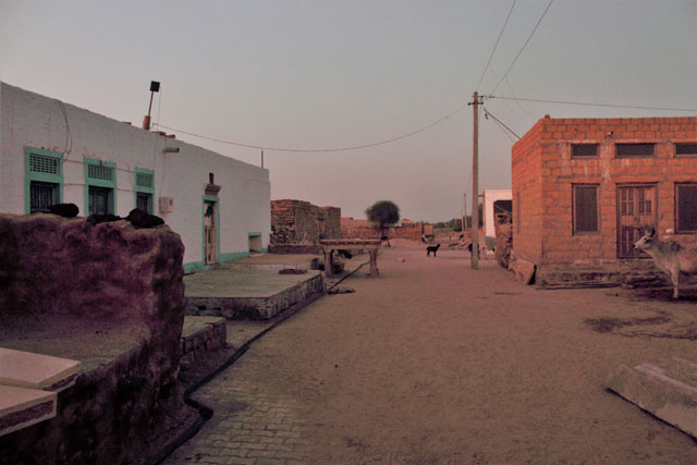
Rajasthan, the largest state of our country, is spread from the valley of Indus in the west to the plateau of Bundelkhand in the east and from the sandy tracts (south of Sutlej) in the north to the Vindhyas in the south. For centuries, it has nurtured various clans of Rajputs, who built a large number of forts both big and small across its length and breadth.

The genesis of fort building in India can be traced back to the Mauryan period. Arthashastra of Kautilya describes six major types of forts, of which the one that dominates Rajasthan is the Giri Durg or Hill Forts. Giri Durgas were further divided into three sub-types: Pranta Durg (built on a flat hill summit), Giri Parshva Durg (spread over the summit and slopes) and Guha Durg (located in a valley surrounded by hills).

In Rajasthan, a series of hill forts stand tall and strong bearing testimony to the power of Rajput princely states that flourished between the 8th and 18th centuries CE. Within these forts, the architecture of palaces and other buildings reflect their role as centres of art and culture.

History:

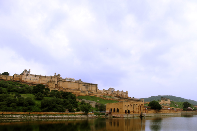
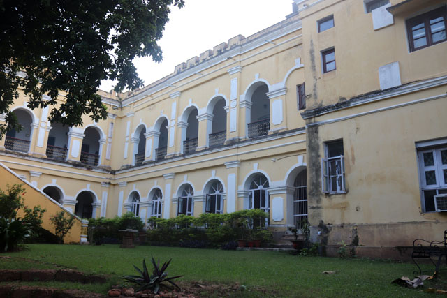
Jaipur, the capital city of Rajasthan and a bustling metropolis is nestled in the lap of Aravali Mountains. Built during 1727 CE by Maharaja Sawai Jai Singh II, the kingdom of Jaipur was earlier known as Jainagara. It is widely known for its three hill forts, Amer, Jaigarh and Nahargarh, built between the 16th and 18th centuries CE. The king of Jaipur is regarded as the titular head of the extended Kachwaha clan.

Kachwahas or Kushwahas are a Rajput clan who built the Amer Fort which is one of the earliest hill forts of Jaipur. Kachwahas claim to be descendants of Kush, the younger of the twin sons of Lord Rama and Devi Sita. The clan originally ruled the Gwalior region of modern Madhya Pradesh. In 986 CE, the Kachwaha King Ishwar Das set off for the Himalayas in search of nirvana. Waiting for just this opportunity was Ishwar’s younger brother who immediately captured the throne and forced his nephews to leave Gwalior. The wandering brothers found refuge and peace in Rajputana. Sodh Rai, one of Ishwar Das’s sons conquered the state of Dausa by attacking and killing the reigning Mina tribal king. After this conquest, Sodh Rai established himself as the new Kachwaha king of Dausa. Sodh Rai was succeeded by Dhola Rai in 1006 CE. His son Kakil Dev founded Amer in the early 11th century CE.

Nothing significant happened in Amer for the next five centuries until 1548 CE, when Raja Bhagmal married his daughter Harka Bai aka Hira Kunwar (wrongly known as Jodha Bai) to the Mughal Emperor Akbar.

amer

amer 6

amer1

Those were uncertain times. The Mughals were still finding their feet while grappling with other Muslim rulers, who were amassing wealth and power in order to oust Humayun. There was also a stiff rivalry between various Rajput rulers. At this critical juncture, Raja Purnamal, Bhaghmal’s predecessor and brother was the first person to realize that Mughals were trustworthy. They were unlike the old stock of Muslim rulers. Under his rule, the Kachawahas became the first allies of Mughals in Rajputana. Raja Bhaghmal extended the cooperation further during his rule.

His son Bhagwat Das who became the Raja of Amer was awarded a mansab of 5000 jagirs by Akbar in 1585 CE. He fought many battles for Akbar and gave his daughter Manbhawati Bai in marriage to Prince Salim, who later came to be known as Emperor Jahangir. These marriage ties between Kachwaha Rajputs and Mughals were the major turning points In India’s artistic history. For along with gifts, artists and architectural styles were also exchanged. Amer Fort stands as one of the wonderful examples of such an exchange as it was built along the lines of Mughal forts and palaces of the time.

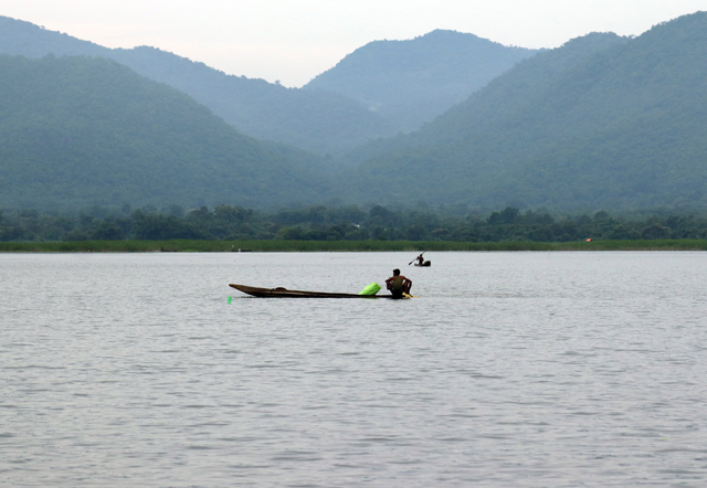
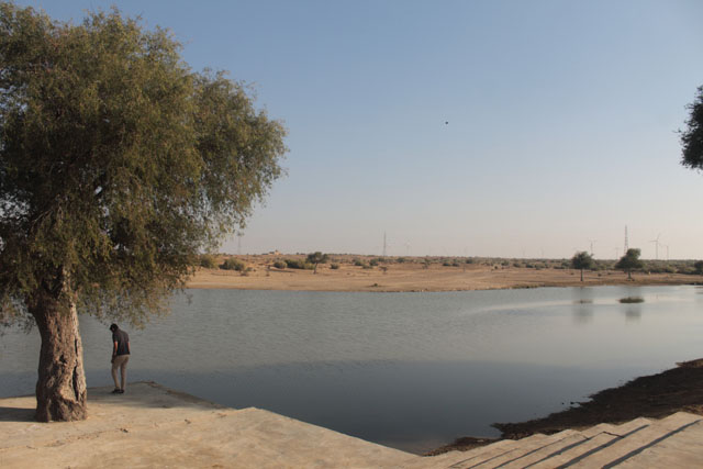
Raja Man Singh, the next in line, executed grand projects within the Amer Fort (1550 – 1614 CE). He was a trusted general of Akbar and one of his Navaratnas (nine gems). Man Singh first constructed the Man Mandir Palace, the oldest block of the fort. He also built the Man Sagar Lake in 1610 CE by damming the Dharabawati River for irrigation and recreation. A palace known as Jal Mahal was built in the middle of the lake. The lake is flanked by hills on its western, northern and eastern sides and covers an area of 300 acres.

Also, Read Here:

Dundlod in Shekawati – A Timeless Heritage

amer7

IMG_5827

IMG_5916

IMG_5937

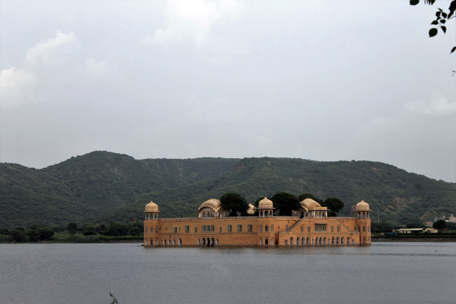
The Splendid Man Sagar Lake and the Jal Mahal

Amer Fort reached a new high under Raja Jai Singh I (1622 – 1667 CE). He built splendid buildings such as the Diwan – I – Aam, Sukh Mandir, Jai Mandir, Jas Mandir and Diwan I Khas. He also modified parts of the old block built by Raja Man Singh. Jai Singh I was an admirer of symmetry and the plan of the city of Jaipur testifies to his vision. In Amer, he laid out beautiful char bhagh gardens near Diwan – I – Khas and over Maota Lake.

Travel Tips

Jaipur is the capital and the largest city of the Indian state of Rajasthan in Northern India. Celebarted as the Pink Coty, it was founded on 18 November 1727 by Jai Singh II, the ruler of Amer, and after whom the city is named. It is located 268 km from New Delhi. Jaipur is a popular tourist destination in India and forms a part of the west Golden Triangle tourist circuit along with Delhi and Agra.

Surrounded by the Aravali Mountains, the city was planned according to Indian Vastu shastra by Vidyadhar Bhattacharya. There are three gates facing east, west, and north. The eastern gate is called Suraj pol (sun gate), the western gate is called Chand pol (moon gate) and the northern gate faces the ancestral capital of Amer.

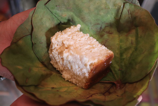
Jaipur is a foodie’s heaven. Try out these local delicacies Typical dishes include Dal Baati Churma, Missi Roti, Gatte ki Sabzi, Ker Sangri, Makke ki Ghat, Bajre ki Ghat and Bajre ki Roti and sweets which include Ghevar, Feeni, Mawa Kachori, Gajak, meethi thuli, Chauguni ke laddu, and Moong Thal.  

IMG_5536

IMG_5585 - Copy

Amer Fort:

Amer Fort is located in a valley formed by a range of Aravali Hills locally known as Kalikho Hills and placed on the hill below the connecting fort of Jaigarh, about 12 kilometer from Jaipur in north direction.

amer4

Amer Fort marks the highest point of Rajput eclecticism and synthesis of Rajput-Mughal planning for palace spaces and gardens, water systems, art work and building craft. It has distinctive vertical layers of planning where the palatial quarters are located in the valley (Amer Fort) and the garrison is located on a higher elevation (Jaigarh) to command the valley.

amer3

The planning of Amer Fort in particular reflects the changing political strategy of the Rajput aligned with architectural planning concepts from Iran and Central Asia introduced by the Mughals. The palace and the fort are protected by fortification with four gates in four cardinal directions. Within the fort walls are found a number of gardens influenced by Mughal Charbhagh style gardens, courtyards and palaces.

Blending the fort with the topography of the Aravali, at the base on the east is the Maota Lake, fed by surrounding streams. It offers a splendid view when seen from above. Maota is derived from ‘Mawat’ or a shower of rain, which fills the lake. Maota Lake had multiple functions. During conflicts, it acted as a natural defense. It provided water to the palaces within the fort (evident from the elaborate system of lifting and tanks as seen in the fort). It also acted as a place of recreation for the royalty.

Also, Read Here:

Datia Palace – Of Friendship, Mystery and Inspiration

IMG_5893

IMG_5901

IMG_5702

IMG_5830

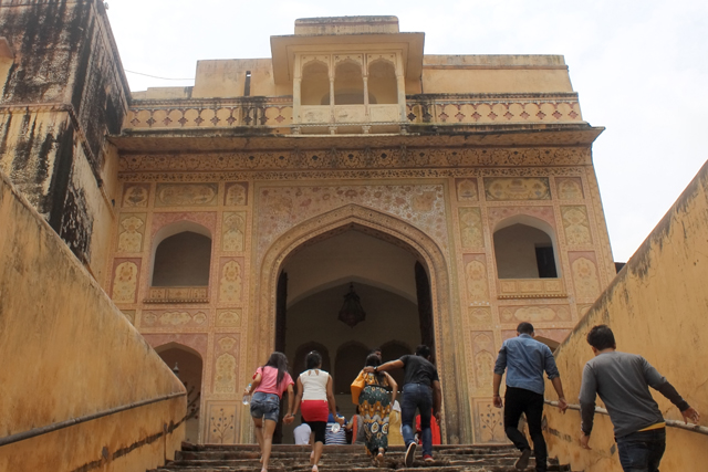
The Diwan – I – Aam and Diwan – I – Khas inside the palace along with the Jaleb Chowk or the public space that is built along a ridge of the hill show distinct influences of  Mughal architecture.

IMG_5591

IMG_5599

IMG_5610
The next significant structure is the Ganesh Pol, a two storied building which serves as the entrance to the private court of the palace. On the upper floor of the gateway is Suhag Mandir, a chamber that was used by the royal women to witness the state functions held below in Diwan I Khas through lattice screens.

IMG_5612

IMG_5615

IMG_5683 - Copy

IMG_5684

IMG_5686

IMG_5688

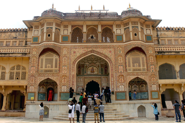
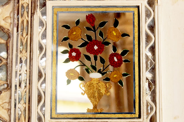
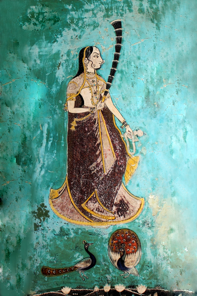
The walls of the entire building are illustrated with exquisite frescoes painted with natural colours using a 900 year old technique called Araash.  White marble dust from Makrana is mixed with slaked lime and pigment to make a paste. Then layer upon layer of the paste is applied to build up the colour. It is then dried and polished. According to experts, Araash decorated walls keep the structure cool in summer and warm in winter. The technique was brought by Christian missionaries during the reign of Akbar and Jahangir and taught to the local artisans of the Khumavat Kshatriya community. When palaces were built, it was the Khumavats who finished the walls and floors with 18 to 21 layers of marble dust and lime, then polished till the walls became smooth. Designs were made at the end illustrating a range of exotic flower vases, and ornamental foliage. The surfaces of the vases were further illustrated with images of court scenes, Rajput palaces and royal lifestyle.

IMG_5620

IMG_5621

IMG_5626

IMG_5629

IMG_5630

IMG_5632

IMG_5681

IMG_5682

IMG_5692

IMG_5693

In 1999, a colonial bungalow was restored in Mumbai and converted into a fine dining restaurant, Indigo. Kate Dineen, the only woman in the world trained in Araash technique, has done up the walls of this much awarded restaurant hailed for its old world charm. Trained under Gyarsilal Verma, a master of Araash, she has taken this highly laborious and lesser known Indian technique to global recognition and accolades (muirnekatedineen).

Another major artistic attraction of Ganesh Pol is the dome or Iwan ceiling decoration. Yazdi bandi is a decorative vaulting architectural pattern consisting of diamond shaped modules of different sizes with very small flat and horizontal star shape pieces in-between. Each tier interlocks with the tier above and below. Popularly called the honeycomb architecture for its striking resemblance to the abode of the honey bees, it is also known as Muqarnas in India. This element of Persian architecture is seen very commonly in scores of Mughal and other Indo-Islamic monuments.

IMG_5617

IMG_5622

IMG_5624

IMG_5625

IMG_5627

After the Ganesh Pol, comes the most splendid part of the fort, Jai Mandir. Completed in 1729 CE by Raja Man Singh, it is an exquisite structure with glass inlaid panels and mirrored ceilings. Also known as Sheesh Mahal, the convex shaped glass panels were designed with coloured foil and paint. In the past when it was in use, it would glitter bright under the candle lights. Think the iconic song ‘Jab Pyaar Kiya Toh Darna Kya’ from the movie Mughal-E-Azam where Madhubala dances in a hall of mirrors.

IMG_5695

IMG_5675

IMG_5671

IMG_5664

IMG_5637

IMG_5647

IMG_5648

IMG_5640

IMG_5642

IMG_5644

IMG_5645

IMG_5646

IMG_5650

IMG_5652

IMG_5653

IMG_5657

IMG_5658

IMG_5659
Known as Thikri, the art of inlaying hand cut pieces of mirrors scaples into perfect shapes and arranging them on walls was a hallmark of Rajput aesthetics. The art is roughly 400 years old and a handful of artisans like Mr. Rajesh Anant of Udaipur are still practicing it (www.glassinlay.in).

Jaigarh Fort:

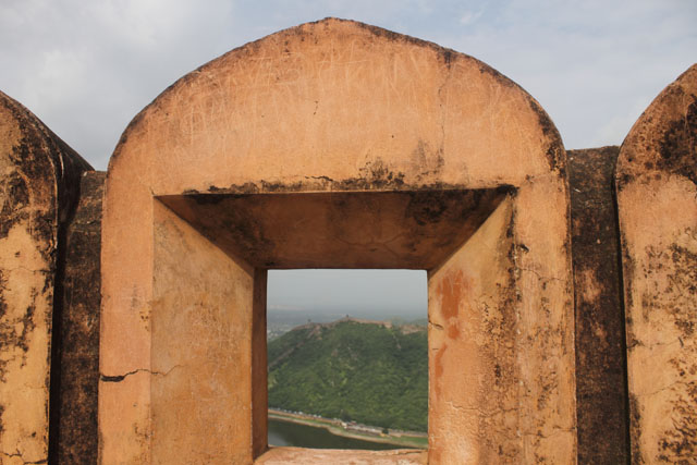
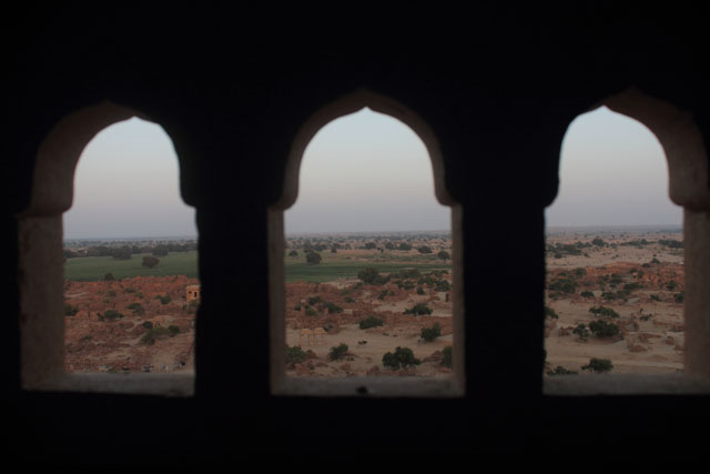
In order to protect Amer Fort and its palaces, Maharaja Jai Singh II built the Jaigarh Fort, 400 metres above Amer Fort in 1726 CE. Also known as the Victory Fort, it is 3 kms long and 1 km wide. The major attraction of this fort is the canon ‘Jaivana’. It was the world’s largest canon when it was built. The fort is heavily fortified with thick walls of red sandstone. Within it there are palaces with courtrooms and halls. A major draw of these rooms is its pretty lattice screens. Water was supplied to the fort from Sagar Lake, built below the hills for rain water harvesting. Water from the lake used to be transported to the fort in pouches loaded on elephant backs and also by humans. Jaigarh is a garrison fort and has one of the largest armories of the country.

amer6

IMG_5854

IMG_5899

amer5

IMG_5831

IMG_5840

IMG_5848

IMG_5853

IMG_5902

IMG_5908

Nahargarh Fort:

Nahargarh is the last in the series of Jaipur forts that is perched on an Aravali crest just above the pink city. Nahargarh, which translates as the abode of tigers was built in 1734 CE by Maharaja Jai Singh II. This fort has not seen a single battle. However, during the 1857 mutiny, several British officers took refuge in Nahargarh with the help of Maharaja of Jaipur, Sawai Ram Singh.

nahargarh1

nahargarh2

nahargarh3

nahargarh4

IMG_5817

IMG_5815

IMG_5809

IMG_5801

IMG_5786

IMG_5788

IMG_5772

IMG_5748

IMG_5742

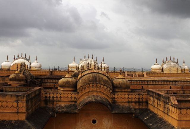
Nahargarh has some splendid mansions within its walls, prominent one being the Madhavendra Bhavan. The two storied palace is divided into 9 apartments and each one of the 9 apartments is again two storied. Artistically, these reflect a fusion of Indian and European styles unlike other forts where Persian influence is distinct. The fort offers a panoramic view of the Jaipur city.

The hill forts of Jaipur are testimonies of a time, when two ideas met to establish a new identity for India in terms of art, architecture, music and dance. While the other hill forts of Rajasthan fell into decay, the Jaipur Forts not only survived but carved out a path for Jaipur to evolve as India’s first modern planned city. Today when the country is torn apart on the grounds of religious differences, the Jaipur Hill Forts stand tall as sources of inspiration for religious tolerance and acceptance, much needed ideas to upkeep the secular fabric of India.


Author – Jitu Mishra

He can be contacted at jitumisra@gmail.com