Mundigada – Your Wanderlust in Kandhamal (Part 2)

When you are at Mundigada you don’t see any glamorous monuments around you. But you hear stories of its hoary past. You are bound to contemplate, is the history of Odisha or India just restricted to the glory of Mughals or Gajapatis…why we don’t hear the stories of unknown India. Here is an attempt!

IMG_6747

The Kondhs are a militant tribe and don’t want to interfere in their territory. In the past, they were virtually independent in their mountainous kingdom but also connected by alliances with the ruling chiefs from the plain, especially Ghumsar. But when the chiefs tried to exert their political influence over them, the Kondhs resisted violation which in course of time led to Kondh uprising against the rulers of the plain and the British Raj in the 19th century.

IMG_8867

IMG_8240

IMG_8244

IMG_8911

IMG_6515

A forgotten chapter in history, the Kondh uprising predated even the much-talked mutiny of 1857.

There are three causes of Kondh uprising.

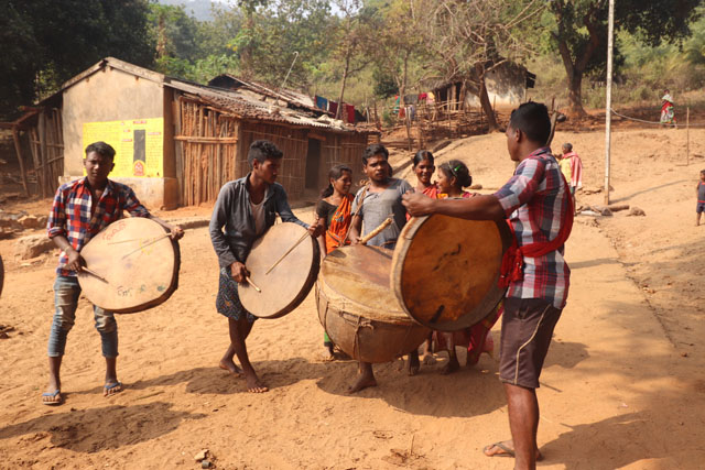
The first is the tradition of human sacrifices, called Meriah. The Kondhs were first brought to the notice of the British during 1835-37 through the Bhanjas of Ghumsar. In February 1836 the British force for the first time, while ascending the ghats, came to know about the existence of human sacrifice among the Kondhs of the hill tracts of the present-day Kandhamal including Mundigada. The British did not like the barbaric practice and wanted to abolish. But the practice of human sacrifice was the foundation of their socio-religious life. Therefore the British authorities took many cautious steps in dealing with the problems. Interestingly, the officers exerted their influence in making the Kondhs understand the norms of civilised life. They would come in elephants through the dense jungles and crossing several mountains and mountain rivers and assemble in a field at Mundigada to interact with Kondhs.

Also, Read Here:

MUNDIGADA – YOUR WANDERLUST IN KANDHAMAL (PART 1)

It is said that through direct inducements, such as gifts of land, money and cattle, titles and employment in the company service, the Kondhs were influenced. Even they tried to influence the priests of the Kondhs. But all such attempts were miserably failed to produce a due effect on the Kondh tribes. The practice of Meriah was so deep-rooted in Kondh society that any attempt by the British to suppress it created a sharp reaction among the Kondhs.

IMG_8504

IMG_8846

IMG_8856

IMG_8901

Kondhs have 84 deities of whom ‘Thadi’ or ‘Teri Penu’ is the supreme. The Kondhs would be united in a ceremony in the worship of this deity. There would be sometime a child with a belief that the earth would become stable and fit for ploughing. Their prosperity would be ensured.

Travel Tips

Mundigada is a small village located in Tumudiband Block of Kandhamal District at a distance of 5 km from Tumidibanda and 50 km from the Subdivisional town of Baliguda. Connected by excellent road and bus service, the state capital of Bhubaneswar is 350 km away from Mundigada. At Mundigada, you can stay at Sathi Ghara Mountain Home, a homestay specially designed for knowledge seeking travellers.

When the British authority failed to persuade the Kondhs to give up Meriah sacrifice, they decided to use force against them. But due to high altitude difficult terrain, it was not feasible. The British interference in their socio-religious rites led to prolonged states of warfare.
IMG_6539

IMG_8881

The second cause was the forced taxation. Ghumsar was in a state of political turmoil from the time the British captured it in 1767 till the end of Ghumsar rising in 1837. During those 75 years, Ghumsar faced desolation, devastation and ruin. There was the failure of crops in 1836 and consequently scarcity throughout the state. The following three years were of bad harvest for the whole of Ghumsar Kingdom. It crippled the backbone of people. On top of it, the British authority levied heavy taxes on rajas of Ghumsar and Baud. The government demanded arrears and revenue from the rajas, who in turn tried to realize the amounts from the Kondh inhabitants. But the Kondhs considered themselves the owner of the soil and they would not part with their lands on any ground whatsoever.

Also, Read Here:

A JOURNEY THROUGH KONDH TERRITORY, A TRIBE THAT ONCE SACRIFICED HUMANS

The Kondhs apprehended that their land would be grabbed by the British. They were against the imposition of any land revenue or taxes when they and their ancestors have not been in the habit of paying.

The British officers and the local agents with the instruction of the Government imposed illegal taxes on the Kondhs. To extract the money from them, even their cooking utensils were carried away forcibly.

The condition of Kondhs gradually worsened. Consequently, the oppressive rule was no longer tolerable, the Kondhs violently revolted against the British authority.

The third cause was to maintain political autonomy of Kondhs. The Kondhs carried on prolonged warfare against the British for upholding the prestige of the native people. Chakra Bisoi, a Kondh rebel took the leadership of the Kondhs. He established Lakshmi Narayan Bhanj, a scion of the royal family as the new ruler of Ghumsar against the wishes of the British Government. Such a move immediately attracted the attention of Kondhs, who eventually fought for the re-establishment of the native rule, in which it was believed their privilege could be safeguarded and grievances removed.

Today Mundigada is transformed, its native, especially the new generation has forgotten its pride history. Thanks to Sri Suresh Patra, who in this film narrates an incident of Kandh rising near Munigada in the 1850s.

Author: Jitu Mishra

He can be contacted at jitumisra@gmail.com

Bliss in the Wilderness – Lulung Aranya Nivas

2 million years ago! Our species Homo sapiens did not exist then. The earth’s climate and the terrain looked very different from now what you see. In Odisha, which today is the most populated region, the coastal plain was all under seawater. Around that time, however, in the eastern part of Similipal, close to the present Budhabalanga River and its tributaries, had witnessed a spurt of activities by a band of Homo erectus, a species of ape in human evolution that had evolved in Africa and had spread in parts of Asia and Europe, in search of food. Homo erectus used sharp stone tools and lived on hunting and gathering. Kuliana, a modern village near Baripada was one of their earliest homes in Indian Subcontinent.

IMG_2741

IMG_2745

IMG_2672

IMG_2692

IMG_2664

The periphery of Similipal, Odisha’s Earliest Human Settlement

In the high-tech 21st century it is difficult to imagine how would be the landscape in the remote Stone Age and what other animals coexisted with them. The entire area must be a thick jungle and a major watershed in North Odisha Highland.

Today, one does not get disappointed, thanks to the existence of a large forested region, called Similipal, one of the 11 UNESCO declared biospheres in India and a major tiger reserve.

IMG_2652

IMG_2658

IMG_2657

Lulung forms of Similipal’s eastern border and entrance to its core area. Surrounded by lush green forest, sky touching mountains, sprawling meadows, gushing rivers and streams and tiny hamlets of local Adivasis, Lulung is Similipal’s best-kept secret. Here bliss meets wilderness in perfect harmony.

IMG_2531

Travel Tips

Lulung is the entry point of Eastern Similipal near Pithabata Gate at a distance of 22 km from Baripada Town and 273 km from Bhubaneswar. There are regular buses from Bhubaneswar to Baripada throughout the day and night (6 hours). One can also take a train from Bhubaneswar to Balasore and then a bus for Baripada. From Baripada one can reach Lulung hiring an auto-rickshaw.  For Aranya Nivas, one needs to book through online (https://simlipalforestresort.com/)

IMG_2504

IMG_2500

The pride of Lulung is, however, its star attraction Aranya Nivas, a luxury resort in the lap of nature. Spread over an area of 18 acres, the resort is an ultimate home in luxury for the soul seeking travellers.

IMG_2439

Similipal once used to be the hunting ground for the Maharajas of Mayurbhanj was declared as one of the first tiger reserves in India in 1956 and project tiger in 1973. Spread over an area of 2700 square km, Similipal is one of India’s densest Sal forest. The tribal communities of Ho, Munda, Bhumija, Santhal and Mankadia live in the buffer area. The forest of Similipal falls under Eastern Highlands Moist Deciduous Forests Ecoregion with tropical moist broadleaf forest and tropical moist deciduous forests.

Also, Read Here:

ATHMALLIK – IN THE HEARTLAND OF MAHANADI WILDERNESS

IMG_2514

IMG_2518

IMG_2452

The indigenous people living inside Similipal and its periphery live harmoniously with jungle. They don’t allow anybody to damage the forest resources that they have been depending upon for ages.

IMG_2754

According to their belief, Ban (Forest) Devta (God) guards their forest and protect them from diseases and natural calamities. A bunch of terracotta horses and elephants guard Ban Devta, who has shrines under large Karma trees.

IMG_2431

Karma dance and songs are performed in honour of Karma Devta. Both men and women go to the jungle accompanied by groups of drummers and cut one or more branches of the Karma tree after worshipping it.

Also, Read Here:

MYSTIC NILAGIRI – THE ABORIGINAL HEARTLAND OF BALASORE WITH A ROYAL PAST

IMG_2323

IMG_2256

A legend goes: seven brothers were living together. The six elders would work in the field and the youngest would stay at home. He would entertain in dance and songs around a karma tree in the courtyard with his six sisters-in-law. One day, they were so engaged in dance and song that the brothers’ lunch was not carried to the field by the wives. When the brother arrived at the home they became agitated and threw the karma tree into a river. The youngest brother left home in anger. The evil days fell on the remaining brothers. Their house was damaged, the crops failed and they virtually starved. While wandering the youngest brother found the karma tree floating in the river. Then he invoked the god who returned everything. Thereafter he returned home and called his brothers and told them that because they insulted Karma Devta, they fell on evil days. From then on Karma Devta is worshipped with full devotion.

Also, Read Here:

DHENKANAL – WARS, WILDERNESS AND ROYAL HOSPITALITY

IMG_2591

IMG_2629

IMG_2633

IMG_2650

The worship of Karma Devta shows the deep respect for forest among the local Adivasis. At Aranya Nivas, the tribal faith is truly appreciated. The shrine of Ban Devta which fell inside the resorts before its construction is not only restored but is allowed for regular worship by the locals.

IMG_2433

Everyday evening a special programme karma dance is arranged for resident guests. As the dark shrouds after sunset, the swing of women dancers accompanied by soulful Karma songs with the beating of dhols by their male companions around sacred fire drive everyone liberating themselves into uniquely crafted human stories with worshipping nature forming the centre stage.

IMG_2350

IMG_2374

The luxurious resort of Aranya Nivas is a plant lover’s paradise. From Spider Lilly to Lemongrass and from Fern to Temple Grass and Japan Lilly, the surrounding of walking paths of the resort’s sprawling meadow area is a treat to eyes.

IMG_2551

IMG_2553

IMG_2557

IMG_2565

IMG_2568

IMG_2571

IMG_2577

IMG_2579

IMG_2395

IMG_2404

Similipal is notoriously known for malaria though it is reduced now drastically. However, Lemongrass plants are tastefully planted as screen guards before each suit of the property to ensure protection from mosquito bites.

IMG_2521

IMG_2419

The poolside of the resort is a place to rejuvenate with.

IMG_2536

But what you cherish most is the gushing sound of the river throughout the night and the morning transforming your suit’s neighbourhood into a musical aura.

IMG_2544

IMG_2448

IMG_2453

The gastronomic experience at the resort is the icing on the cake. On regular intervals, you are served the best of herbal tea.

IMG_2522

IMG_2524

IMG_2528

Truly Lulung Aranya Nivas is bliss in the wilderness.

Author – Jitu Mishra

He can be contacted at jitumisra@gmail.com

Kandhamal – Heritage in Wood

They call themselves children of Kui Dina (Kui Country) and for outsiders, it is Kandhamal (named after Kondh Tribe). Thousands of square miles of rolling hills and dense jungle, Kandhamal is a nature lover’s paradise. Her forest is rich in majestic Sal trees followed by Piasal, Kendu, Gambhari, Kusum, Harida, Bahada, Amla, Mango, Tamarind, Mahua, and many more.

IMG_1278

IMG_1249 - Copy

IMG_1187

The forests of Kandhamal can be classified as dry and wet deciduous forests depending upon the season you visit. On its deep valley mountain floors, there are hundreds of villages of Kondh Tribe scattered around the deep jungles. The 19th-century British romanticists referred to this area as ‘Kondhistan’.

IMG_1692

IMG_1602

IMG_1636

The Kondhs speak in a Dravidian language called ‘Kui’ which is spoken in an extreme nasal form.

IMG_1192

The utilisation of forest wood is an integral part of their heritage. Their houses are made of wooden posts plastered with mud. Their settlements are fenced with wooden posts erected in a line, some time for hundreds of meters.

Also, Read Here:

BARBARA FOREST – A BLEND OF NATURE, INDIGENOUS CULTURE AND ARCHAEOLOGY

IMG_1218 - Copy

IMG_1224 - Copy

IMG_6269

IMG_1055

When you get into their huts you will be surprised to discover most of their material objects, such as plough, yoke, spade, pounding posts, and bells for cows and goats, are made of wood.

IMG_6216

IMG_1226

IMG_1223 - Copy

IMG_3973

However, what strikes you most is their Meriah Sacrifice wooden posts. The Kondhs in the interior hills practises Meriah sacrifice (earlier they would sacrifice a human, now a buffalo).

Also, Read Here:

A JOURNEY THROUGH KONDH TERRITORY, A TRIBE THAT ONCE SACRIFICED HUMANS

IMG_1048

IMG_1051

IMG_1053

IMG_1097

The term Meriah is a corrupt form of the Kondh term ‘Mervi’, which refers to the Kondh God Mervi Pennu, a brother of the Earth Goddess Tari Pennu. The Kondhs believe that buffalo sacrifice would give them good crops and protection against all diseases and natural disaster. The buffalo is purchased and brought to the middle of the village. After worshipping earth goddess and the victim, the buffalo is tied to a wooden pole.

IMG_1333

IMG_1335

IMG_1339

IMG_1340

IMG_1346

IMG_1206 - Copy

The victim is decorated with flowers and vermillion. Then the Kondhs bring their knives and tangi (axe) and after getting intoxicated they sing and dance around the victim for a few hours. Then at a particular moment, the priest (Jani) signals and all of them (numbering between 30 and 50) hit the buffalo at the same time. The blood stuck to the instrument is considered auspicious and the instrument would prove ultimately to be very lucky, efficient and productive that year.

Throughout this event, the Kondhs assign the buffalo the supernatural soul carrier. Inside many Kondh traditional houses you will find buffalo horned wooden posts showing nice carved designs (clan marks), which are worshipped as symbols of the household ancestors.

IMG_1264 - Copy

Interestingly, the Hindu God of Death, Yama is also associated with water buffalo acting as a mythic vehicle (vahana) to the ether world. Archaeological interpretations also suggest that sacrifices of buffalos were seemingly performed by the people of the Indus Valley Civilisation for some unknown religious rituals. Today, not only Kandhamal but in many parts of Eastern India, buffalo acts as the chief sacrificial animal in a class of structurally related death and ancestor worship ceremonies.

Travel Tips:

Baliguda is at the heart of Kandhamal strategically located on the highway that connects Bhubaneswar with Rayagada, Kandhamal and Kalahandi. Most of the Kondh villages are around Baliguda, which has also decent staying options. The village of Podpada is before Baliguda (20 km) on the highway from Bhubaneswar. It takes about 7 hours in a private vehicle to reach Baliguda. There are also comfortable night buses. The other option for stay is at Daringibadi, a popular tourist place among Indians located at a distance of 50 km from Baliguda.

The Baliguda region of Kandhamal, which also forms the core of Kui Dina, was under the rule of the Gangas from the 10th century and under the Bhanjas of Ghumsar from 18th century until the time it was annexed by the British in the mid 19th century. During the reign of the Bhanjas (18th-19th centuries), Kandhamal also saw architectural activities, similar to the coastal plains of Odisha.

IMG_0962

IMG_0963

IMG_0964

IMG_0974

IMG_0987

IMG_0967

One major aspect of the architectural tradition is the extensive use of wood carvings in-ceiling and doorjambs, similar to ones found at Biranchi Narayan Temple at Buguda.

The Nrusingha Temple at Podapoda Village on the highway that connects Phulbani with Baliguda is the only remains of rich wooden heritage. Though mostly gone, the temple has been known for its wooden gems featuring Tantric rituals and geometrical motifs on its lintel. Unfortunately, its roof is replaced with tin sheets now. Depiction of peacocks forming a circle at the central part of the lintel is a major draw. Besides, there are representations of garudas and monkeys noticed in the interior of the structure.

Also, Read Here:

ILLUSTRATING RAMAYANA KATHA – BIRANCHI NARAYAN TEMPLE AT BUGUDA

IMG_1008

IMG_0977

IMG_1009

IMG_1012

IMG_1013

IMG_1021

IMG_1030

IMG_1031

IMG_1034

The wooden heritage of Kandhamal is truly unique, but sadly many of its priceless treasures are in a sorry state of preservation due to lack of patronage and loss of interest among Kondhs. To save them we need a strategic plan inviting heritage conservationists, historians, travel professionals and of course involving local stakeholders, such the community members of Kondh Tribe and non-Tribal communities.

Author – Jitu Mishra

He can be contacted at jitumisra@gmail.com

Athmallik – In the Heartland of Mahanadi Wilderness

Imagine 19th century Mahanadi, a river that formed the lifeline of Odisha and the only passage to commute between Sambalpur and Cuttack and further Puri for Jagannath darshan. Mahanadi looks pristine but at times could turn hostile for sailors, thanks to its floor filled with large and small rocks that could cause accidents if you are not a skilled and vigilant captain.

IMG_0498

Flat bottomed boats that float even today are well suited for Mahanadi navigation. The boatmen would carry racks and hoes with which they would clear a narrow passage just sufficient to let their craft pass, where there were chances of rocks impeding navigation.

Also, Read Here:

SPLENDOURS OF SONEPUR – IN THE LAND OF RAMAYANA’S LANKA

IMG_0500

IMG_0458

The people living on the banks of Mahanadi subsisted by river trading. They would carry salt, spices, coconut and brass utensils from Cuttack to Sambalpur in exchange of cotton, wheat, oilseeds, clarified butter, oil, molasses, iron, turmeric and ikat cloths.

Everything would go fine till they reach near Athmallik where Mahanadi would become a gorge, now flowing like a snake amidst densely forested hills of the Eastern Ghats in the south and Gadajat in the north. The river here is also infested with gharials, the Indian counterpart of American alligators. To gain courage and for safe passage in the gorge, the boatman would seek the blessing of Maa Binkai and Maa Konkai, two sister goddesses, whose abodes are separated by the river.

Also, Read Here:

BADAMBA – EXPLORING THE MIDDLE MAHANADI KINGDOM

IMG_0485

IMG_0507

IMG_0467

IMG_0479

IMG_0466

IMG_0464

Dramatic Setting at Binkhai

Today this may sound like a fairytale, but when you are at Binkai your soul is simply transported to yet another era of mysteries and courage of river people amidst the breathtaking collage of mountains and river.

Travel Tips

Athmallik is located at a distance of 192 km from Bhubaneswar and it takes about 5 hours of drive on a scenic highway. However, one can also take a train up to Boinda from Bhubaneswar (the best option could be Bhubaneswar – Bolangir Intercity, which leaves Bhubaneswar at 6 AM and arrives at Boinda at 9.30 AM). From Boinda if informed priorly, Anupam Dash can arrange a vehicle for pick up. His phone no is +91 9937412336.

Deep Forest Farmstay is about 40 km from Boinda Station. The drive is scenic, especially on the Ghat Road. On your both sides there are majestic Gadajat Hills and mountain streams in the western periphery of Satkosia Wildlife Park.


IMG_0448

IMG_0445

Athmallik located in the geographical centre of Odisha is the closet town from Binkai. Steeped in history, Athmallik was a princely state at the time of British Raj. Nestled on the foothills of Panchdhara Mountains and surrounded by the dense jungle of Hatidhara, the buffer area of Satkosia Tiger Reserve, the origin of Athmallik State is obscure.

IMG_0396

IMG_0324

IMG_0309

IMG_0319

IMG_0314

Glimpses of Panchdhara Mountains and Forest around Athmalik

In the 11th century CE, a jagir was established by King Pratap Deo of the Kadamba Dynasty. Pratap Deo was said to have found a Honda metal vessel which was considered an auspicious sign, after which the territory was named as ‘Hondpa’. Centuries later one of the chiefs divided the state into eight divisions and placed one sub-chief called ‘Malla’ in each division to suppress the unruly tribes. After this event, the kingdom’s name was changed from ‘Hondpa’ to ‘Athmallik’.

IMG_0567

IMG_0326

IMG_0304

IMG_0305

IMG_0313

Folklore goes: Pratap Deo was a royal scion of Amer (Jaipur) who had come to Puri as a pilgrim along with his six brothers and one sister. For some reason, he ran on trouble and lost four of his brothers in a battle against the king of Puri. As there was no chance for survival, he escaped to the jungle of Bonai. Here at Bonai after he settled down without any fear he arranged his sister’s marriage to a scion of Keonjhar royal family. But the marriage did not last long as his brother-in-law was murdered during a conspiracy.

Once again to overcome threats he had to look for a safe place. Fortunes brought him to Boudh on river Mahanadi and then to present Athmallik, further downstream of Mahanadi, which was ruled by 8 mallas or village chiefs during that time.

At the time of British Raj, Athmallik was one among the 26 feudatory states of Odisha. Today what is left of the erstwhile state are the Kishore Bhavan Palace and an older dilapidated palace on the periphery of the town.

IMG_0341

IMG_0516

IMG_0515

IMG_0530

Vestiges of Royal Heritage at Athmallik

The region around Athmallik also has the largest number of hot springs in Asia. There are 84 in Deulajhari, a holy shrine of Lord Shiva, out of which 24 are accessible.

IMG_0373

Deulajhari Shiva Temple

According to local belief before Pratap Deo arrived and when the tribal chiefs still ruled, the Lord Jagannath lived in a cave by a wide-eyed, limbless wooden statue worshipped by the indigenous Sabara people. But one day, Hindu priests arrived along the river by boat and kidnapped Jagannath, installing him at the main temple of Puri, where he has remained ever since.

IMG_0399

IMG_0401

Jagannath Temple Complex in Athmallik

At Athmallik, Jagannath is believed to have once been adorned by what was the largest diamond in the world, before becoming known as the Koh – i – Noor.

The Panchadhara Mountain Range covers a vast area of dense forest and is a prominent elephant corridor. A major watershed, the hills run in parallel to Mahanadi. The mountain range is named after being the source of 5 perennial streams that flow in different directions before forming tributaries of Mahanadi. There are splashing waterfalls deep inside the forest.

IMG_0609

IMG_0333

IMG_0332

IMG_0425

Oriental Scops Owl

IMG_0325

Deep Forest Farmstay

A major attraction of Panchdhara is Deep Forest Farm Stay, a destination itself for nature-loving travellers. Spread over a land of 4 acres the property has been crafted by Anupam Dash, an avid wildlife photographer and a passionate naturalist. The facility is located in the buffer area of Satkosia Wildlife Sanctuary in Hatidhara Forest. As you take the winding forest road with the mountain streams in the backdrops, the Deep Forest Farmstay welcomes you to its abode with open arms.

Author – Jitu Mishra

He can be contacted at jitumisra@gmail.com

Mystic Nilagiri – The Aboriginal Heartland of Balasore with a Royal Past

A legend goes: About 1000 years back two Rajput brothers namely Nila and Shankar who belonged to the royal family of Chottanagpur had come to Puri to seek devotion of Lord Jagannath. They were handsome and brave but were suffering from the family dispute at home. The Gajapati King of Puri was highly impressed with their personality and asked them to stay back.

IMG_6468

Both were offered the present Nilagri region in the western part of Balasore to rule. However, Nila stayed back and Shankar left for some other place. The kingdom was named after Nila as Gada Nilagiri.

Also, Read Here:

KHANDAPADA – A VALLEY AMIDST NINE MOUNTAINS

IMG_6478

IMG_6479

It is believed that the present-day village of Gadadih, some 15 km away from present Nilagiri Town was their capital. However, there is no archaeological evidence to support this.

IMG_6489

IMG_6490

IMG_6445

IMG_6436

Time moved on. Several of Nila’s heirs ruled Nilagiri than on. In the 16th century, one of his descendants who ruled Nilagiri was Raja Narayan Basant Bhujang Mandahta. He was a brave king and acted as a commander of Puri Gajapati King in his expedition against the Muslim invaders. Because of his skills and personality, he was offered to marry the daughter of Gajapati King, Princess Kalara Devi. From then on Nilagiri kingdom was influenced by the Jagannath Cult and culture of Puri. Because of his bravery, Raja Narayan Basant Bhujang was also awarded the title Harichandan by the Gajapati King.

Also, Read Here:

BADAMBA – EXPLORING THE MIDDLE MAHANADI KINGDOM

IMG_7019

IMG_7017

IMG_6470

IMG_6466

Narayan Basant Bhujang was succeeded by Raja Uttareswar. According to sources, Uttareswar had assisted Raja Mansingh of Amer (the present-day Jaipur in Rajasthan) in his expedition against the Afghans in Bengal on the banks of Subarnarekha River. Like his father, he was also a great admirer of Gajapati King at Puri. His successor Raja Krushna Das was awarded the title of Mardaraj by the King of Puri and it is still continued.

Travel Tips

Nilagiri is located at a distance of 20 km from Balasore in the periphery of Kuldiha Wildlife Sanctuary. Though it is a small town it does not have much-staying options. The nearby Panchalingeswra shrine located within Kuldiha has a number of staying options including the Panthanivas of Odisha Tourism. You can hire an auto or a cab from Balasore to travel around Nilagiri which can be covered in one day. Hotel Sagar and Hotel Tarini both located in the town serve decent local food in local style.

It is still not known what happened in the next two sanctuaries. In early 19th century, the capital was shifted to the present location under the foothill of majestic Swarnachuda Mountain and named it Nijagada.

Also, Read Here:

DASPALLA – A JOURNEY THROUGH ODISHA’S UNTAMED FRONTIERS

Today the star attraction of Gada Nilagiri is the 19th-century ruins and the added 20th-century palace built in the fusion of Rajput, Odia and Victorian styles. The main attraction of the palace is its high clock tower. Beside the clock tower is the beautiful chhau mandapa, an influence from Mayurbhanj introduced in the kingdom in the 19th century.

IMG_6440

IMG_6444

IMG_6447

IMG_6449

IMG_6450

IMG_6451

IMG_6454

IMG_6455

IMG_6457

IMG_6459

Nilagiri lost its power immediately after India got independence and merged with the Indian union.

Like all princely states of Odisha, Nilagiri is also modelled after Puri. Beside the palace is the temple of Jagannath facing the Grand Road (Bada Danda), a wide corridor through which the chariot festival of Lord Jagannath takes place in every Asadha Month. Like Puri, the trinity of Nilagiri also goes through the new embodiment of bodies (nabakalebara) during the same period. Towards the end of Bada Danda is situated the temple of Mausi Maa.

IMG_6467

IMG_6462

IMG_6442

IMG_6425

Nilagiri is surrounded by the wilderness of Kuldiha Wildlife Sanctuary, lush green forest and enchanting hills. Archaeological evidence suggests that the area has been inhabited from the time of Early Stone Age. At present, there are villages of Bhumija and Madia Tribes, both Austro-Asiatic speaking communities.

IMG_7083

IMG_7076

IMG_7069

Bhumijas are an agricultural tribe and do occasional hunting. They are fun-loving and deep believers in nature. Salabani, a small village on the lap of nature is a major Bhumija settlement near Nilagiri. A visit to Salabani is like a journey back in time where you relive yourself in the old-world charm of Karma dance and music.

IMG_6933

IMG_6937

IMG_6940

IMG_6956

IMG_6932

Babandha, a small village on the bank of Bugulibandha wetland in the periphery of Kuldiha Sanctuary is yet another hidden secret of Nilagiri. Inhabited by 350 Madia potters, Babandha is known for its unique earthen pot rafters. It is said that the community had migrated from Central India about 150 years back on the invitation of the royal family of Nilagiri.

IMG_7050

IMG_7056

IMG_7106

IMG_7120

IMG_7148

Apart from the pot rafters, the surroundings of the village along the wetland area known for its tranquillity and age-old fishing practices.

Nilagiri is mysterious. It seems the time has stood here still for a soul searching traveller. It is tranquil and is the best-kept secret of Balasore in North Odisha.

IMG_6925

IMG_6477

Author – Jitu Mishra

He can be contacted at jitumisra@gmail.com

Gonasika – Odisha’s Dreamtime Stories

The scenery is lush as far as your eyes can stretch! There are mountains of incredible beauty soaked with the floating clouds of the monsoon. You are reminded of Kalidas’s Meghadootam here, each rain-bearing cloud acting a messenger of love and passion. Numerous streams flow through them cascading the slopes and the valley floors. Mysterious forests of Sal trees once filled with tigers and leopards wrap this Dreamtime landscape. You hear countless elephant stories when you talk to country souls of this enchanting land.

IMG_2922

IMG_3152

IMG_3225

As I drive through this unexplored Shangri-La in Odisha’s Keonjhar, I am dragged to her myths – long ago, the land where I am now was floating for millions of years. However, with god’s grace, the hills of Gonasika and its neighbouring hillocks were stable. In good old days there lived a rishi in Gonasika. He was a bachelor. One day while he was resting he heard someone approaching him. There was a girl of Asur Tribe who had come in search of solitude. Both fell in love at first sight. In no time they got married and in course of time delivered seven sons and seven daughters. Now the problem was how to settle them. The hill of Gonasika was inadequate for their shelter and provides food. They required cultivable fields.

IMG_3047

IMG_3056

IMG_2939

IMG_2955

IMG_2963

With no other options, the couple prayed to the Almighty.

Dharam Devata appeared and instructed the rishi to slaughter the Kapila cow and sprinkle her blood to make the earth steady. The rishi brought the cow to Gonasika and killed her. Then he sprinkled her blood on the earth. The earth thus became stable making it suitable for rishi’s children. They were first Juangs on earth.

IMG_2995

IMG_3001

IMG_2988

IMG_3019

After killing the cow, the first Juang family relished the meat and buried the head in the middle of the hill, but suddenly water sprang from the nostrils of the cow and gave birth to the sacred river Baitarani.

Travel Tips 

Gonasika is located at a height of 3000 feet from sea level in Keonjhar District of North Odisha. Surrounded by lush mountain valleys and majestic hills of Chotanagpur Plateau, Gonasika can be approached by road from Keonjhar (25 km) through the National Highway that connects Mumbai with Kolkata. It takes about 2 hours from Keonjhar through a leisure drive with a number of stopover in-between. There are no stay and food options at Gonasika. We recommend Nature Camp at Sana Ghagra near Keonjhar for accommodation, which can be booked through online.  While there are plenty of Juang Villages around Gonasika, we recommend the village of Kadali Badi which has retained some of the anarchic characters of Juang culture. It is situated at a distance of 7 km from Gonasika.

IMG_2892

IMG_3002

IMG_3003

IMG_3007

IMG_3030

IMG_3038

The Juang, an aboriginal tribe of Keonjhar revere Gonaskia as their original mother and the place of their origin. Their villages are around Gonasika and Kanjipani on hilltops or slopes or on valleys amidst hills and forests all around. The Juang villages are located near streams and River Baitarani. Mostly settled farmers now they were portrayed very differently by the 19th century British historians and anthropologists as the wearers of leaf dresses. They are medium in stature with a long head, prominent cheekbone and broad nose showing affinity with the tribes living in the Mon-Khmer region of Mainland Southeast Asia. Their language is Mundari belonging to Austro-Asiatic language group spoken in parts of Eastern India and Mainland Southeast Asia.

Also, Read Here:

BONDAS – THE LONELY SURVIVORS AMONGST EARLIEST INDIANS

IMG_3122

IMG_3044

IMG_3060

IMG_3061

IMG_3145

IMG_3148

During the time of Hunter’s visit in 1877, this account reveals – ‘the men wear a single cloth. The women had not even this, but simply strings around their waist, with a bunch of leaves before and behind. The life they live best is to wonder about the wood collecting wild products which they barter for food.’

Today, this may sound a fairytale as the Juangs have gone a long way of progress, thanks to various government initiatives.

Also, Read Here:

SITABINJI – A MYSTICAL JOURNEY THROUGH TIME AND SPACE

The central attraction of a Juang Village is the dormitory house, called Majanga or Manda Ghara, which also serve as a guesthouse and general assembly place. Their traditional musical instruments and weapons are also displayed here. In front of the Majanga, there is a spacious ground or plaza where the Juang boys and girls dance with their changu (circular drums).

IMG_3063

IMG_3064

IMG_3077

IMG_3079

Believers of animistic religion, Juang offers sacrifices of fowls to the Sun God when in trouble and to the earth for a beautiful harvest.

Houses of Juang are small which can accommodate a married couple and their one or two children. Goats are kept in separate sheds made of wooden plants.

Also, Read Here:

A JOURNEY THROUGH KONDH TERRITORY, A TRIBE THAT ONCE SACRIFICED HUMANS

IMG_3095

Close to a Juang village live two or three Gouda (cattle and sheep/goat herders) families. They heard the cattle of Juangs and supply milk to them.

IMG_3172

IMG_3177

IMG_3190

IMG_3197

A visit to their land will expose to the diversity of their agricultural practises. The valley floors and the mountain slopes are filled with varieties of crops like beans, millets and pulses. These add as supplements to their rice diet. They also are fond of eating the meat of all animals except sloth bear, snake, tiger and vulture. During Akhand Shikar or ceremonial hunting on Amba Nuakhai (new mango) eating ceremony they chase other animals in the forest. However, today most of the forest is gone, thanks to the population explosion, infrastructure creations and mining.

IMG_3204

IMG_3220

IMG_3229

Gonasika is Odisha’s own Dreamtime stories with its myriad beliefs and tales. It is truly a traveller’s paradise interested in people and the deep-rooted beliefs in their landscape, forest, rivers and wildlife.

IMG_3027

Author – Jitu Mishra

He can be contacted at jitumisra@gmail.com

Bondas – The Lonely Survivors amongst Earliest Indians

This is the story of the land where Odisha meets Andhra and where the Machkund River has been rippling away for millions of years. Four thousand feet above sea levels, the Konda – Kamberu range, an arm of the Eastern Ghats surrounds this land. Locked on either side by mountains and interspersed valleys, here has survived an aboriginal tribe for thousands of years. Its children call themselves Remos, which means brave men. However, for people living in plains, they are known as Bonda, which means naked or savage.

IMG_0684

IMG_0692

IMG_1162

IMG_1195

This is a magical land with waves of mountains leaning against each other. Clouds kiss their peaks. Singi Arko (the sun and the moon) disseminate their light below through the clouds, mists and sky-touching trees. There are plentiful streams dancing down from the mountains all around the year. Hidden among these creations of God are the settlements of Remos. Here they have roamed for ages, far away from civilisations, cradling their deadly weapons from one forest to another and one mountain to the next. Within this time frozen land Singi Arko plays their favourite game, creating day and night year after year.

IMG_1114

IMG_1109

IMG_1137

IMG_1138

IMG_1139

IMG_1144

IMG_1160

A story goes: it was time when there lived no humans. Dhartin was the first man on earth. Wherever he walked there was tubuk, the soil. Overhead, there was Singi Mahapuru, the Sun God, and on the ground, Tubu Jang, the Earth Mother.

Travel Tips

Bonda Ghati is located in the southern part of Koraput in Malkangiri District. However, tourists are prohibited in Bonda Ghati. To meet Bondas the only possibilities are various weekly haats or markets in different places around Bonda Ghati. Aunkadelli near Machkund on the border of Odisha and Andhra Pradesh is the best option, which is held on every Thursday. Surrounded by hills and forest, the area is a traveller’s paradise. The nearest towns are Jeypur (60 km) and Similguda (80 km). Both have decent staying options. However, we recommend Desia Koraput, an award-winning ethnic resort (http://www.desiakoraput.com) located near Lamtaput. It is designed in traditional architecture.  The nearest airport is Visakhapatnam (180 km). Bhubaneswar, the state capital is 570 Km.

However, when the earth was born there was no soil, no rocks, only the waves rolled across the dark water. The world was a vast pond. And in it lived an enormous wild boar. With his tusks and snout, he raised the tubuk from the bottom of the pond and scattered it on the surface. Wherever the soil dropped down, the earth appeared and wherever it did not fall there developed rivers, streams and waterfalls. The boar stepped onto earth and jumped into the sky. Singi Arko did not exist then. Everything was lost in darkness. The wild boar turned to face the earth and made another huge leap, landing on the top of a young salap palm. He cut two tender branches of the tree and tossed them into the sky. They became Singi Arko. Then the boar took an armful of salap flowers and scattered them in the sky. The stars appeared and eventually the world was created. But there were still no men.

Also, Read Here:

Breathtaking Duduma Falls in South Koraput – A Cultural Sojourn

From nowhere appeared the first man Soma and the first woman Sanki. Each roamed alone through the jungles. Then one day, Soma and Sanki met. They wore no clothes or ornaments. They did not ask each other from where they came, because at that time the earth was one. The Earth Mother Tubu Jung had not been split into different countries, different villages. Hand in hand they wandered away through the jungle. Loves grew between them and from their union were born the first remos.

IMG_1194

IMG_1192

IMG_1197

IMG_1179

IMG_1118

IMG_1128

IMG_1129

IMG_1185

Their land came to be known as Bonda Ghati which consists of 32 villages. Mudulipada is their capital.

Also, Read Here:

Deomali – Offbeat Wonderland

There is an exciting story of how Mudulipada became their capital.

After the earth was created, both men and women wandered freely in jungles feeding on fruits and roots. But there was a problem. The women had to find a private place for delivering babies.  Once, a pregnant woman saw a green salap tree on the gentle slope of a mountain. The tree was covered with thick branches.  Under her cool shade, she delivered a son and a daughter. A deer arrived around that time nearby. The hungry Remo ran after it with his bows and arrows and did not return for a long time. The woman waited patiently and finally doubted on her husband’s selfishness. She thought, her husband might have killed the deer and eaten its flesh without remembering her. She too was hungry. Without bothering about her two newborn babies she went in search of her husband and finally met him.

The babies cried aloud out of hunger. The salap tree under which they had sheltered had a soul. In those days the salap trees did not produce any juice. It had nothing to feed babies with. However, under cover of the earth, its roots had reached the ocean. The tree prayed with great devotion to the Ocean God for help. The Ocean God was pleased and gave the tree a little of its bounty of the water. The water spread through the roots, the trunk and branches of the tree and dripped into the open mouths of the crying babies. It was the juice of the salap that kept the babies alive. They grew old and strong. They became husband and wife and gave birth to 12 son ad 12 daughters. The 12 brothers built their huts in 12 villages and it was these 12 villages that made up the Bonda country. The eldest brother was Nangli Bonda. He established his home in Mudulipara, which became the capital of Bonda country. Some of their descendants became the Gadaba branch of the Bondas and spread into the foothills.

IMG_0858

IMG_0748

IMG_0875

IMG_0881

IMG_0727

South of Mudulipara is Pinajangar, a lofty mountain range hanging precariously above the Duduma Falls, near the weekly haat or market at Ankadelli.  On every Thursday both Bondas and Gadabas descend here in groups to buy and sell their daily needs along with selling the salap drink. Here the travellers meet Bondas who are distinguished for their colourful costumes and shaven heads.

IMG_0785

IMG_0778

IMG_0733

IMG_0711

IMG_0708

IMG_0707

IMG_0703

When a Bonda boy becomes 5 years old, he puts on a ghusi, a loincloth. At 5, a girl begins to wrap a short ringa around her waist, like a skirt. Her neck and chest are almost hidden under massive strings of beads. She wears beads around her head as well, and on her hands, up to the elbow, she has heavy metal bracelets. Long heavy metal earrings dangle from her ears.

IMG_1108

IMG_0950

IMG_1171

IMG_1172

A legend goes: On those days the perennial Kingubodak Stream gushed down the hillside in the village of Mahulipara. The mango trees along its banks drifted in the cool shade. Sita Thakurani took out her clothes and ornaments and plunged stark naked into the stream’s flowing water. Just then a group of Bonda women descended from the nearby mountain. They did not walk naked then. They had worn clothes and their long hair were oiled and combed into sleek buns.

As Sita Tkakurani emerged from the stream, a hornbill flew overhead screeching as though laughing at her nakedness. The Bonda women could not ignore its call. ‘Phish,’ they burst out laughs. Sita Thakurani cried out in rage. “Can you being women, laugh out at the sight of a woman’s body? The whole world shall laugh at you in Kali Yuga, the evil times to come. Naked you shall be to everyone! And not a hair shall cover your heads, you shall walk with your heads shaven, bare from head to foot. But beware! If you try to cover up your nakedness or grow hair on your scalps, not a blade of grass will grow on the mountains! Bonda people will be destroyed”.

The Bonda women screamed. Their tears softened the goddess’s heart. She pulled out a single thread out of the border of her sari. ‘Take this a weave a garment for yourself, to cover up your shame in the Kali age. But let it be no wider than the length of this thread, and wear it below your navel and above your thigh’.

(Extracts from ‘The Primal Land’ by Pratibha Ray)

The Bonda tribe of Odisha are believed to be part of the first wave of migration out of Africa about 60,000 years ago. They were the first forest settlers in India, who sometime in the ancient past migrated and settled in an area of about 130 sq km in the wild Jeypore hills, in the present Malkangiri District.  The Bondas continue to speak in their language, Remo, which comes under the Austroasiatic language belonging to the Mundari group. Their children are named after the day on which they were born.  The women prefer to marry men who are younger by at least 5-10 years so that the men can earn for them when they grow old. In the past, the Bondas used to hunt and forage for food in the wild. However, now Bondas practice shifting agriculture in the hills not only for consumption but also to sell the produce in the markets.

Author – Jitu Mishra

He can be contacted at jitumisra@gmail.com


Deomali – Offbeat Wonderland

If you are touring Puri or Gopalpur-on-Sea, perhaps you are not told about the other side of Odisha, which is higher in elevation than Panchamarhi in Madhya Pradesh or Mt Abu in Rajasthan. Deomali or the God of the Mali tribe on Odisha-Andhra border is Odisha’s highest point at 1672 m. A solid rock mass, the peak is a vast tableland overlooking the beautiful countryside of Koraput, a utopia far from the maddening crowd.

IMG_0760

IMG_0768

Deomali during an overcast morning

Rich in animals and high altitude plants including a variety of orchids, Deomali until recently was practically unknown. However, the plateau at its base has been a cradle of indigenous culture and farming heritage of local tribes, such as Mali, Gadaba, Paroja, Kondh and many more.

IMG_0910

IMG_0752

IMG_0736

IMG_0804

Agricultural Communities around Deomali

Deomali is a land of captivating beauty. However, tribal communities that inhabit en route Deomali make the journey more engaging and educative. These communities are considered the original inhabitants of India. They have been carrying forward a legacy of rich and distinct cultural traits for many generations. One of their essential assets is their rich agricultural biodiversity treated of global importance.

Travel Tips

Deomali Peak is located on Odisha – Andhra border near Semilguda Town, which has decent staying facilities. You need a personal vehicle to travel the peak and the surrounding villages including Nandapur. Start early in the morning and return before the evening falls in. There is no food facility at the peak. Plan accordingly. You can alternatively stay at Chandoori Sai or Desia, both award-winning resorts influenced tribal architecture.  They will also arrange your trip to Deomali with prior information.

IMG_0818

IMG_0821

IMG_0829

IMG_0835

It is one of the areas where rice was originated. Even today, the region is celebrated for the genetic diversity of Asian cultivated rice. The traditional varieties grown here are thought to be harbouring dominant genes for biotic and abiotic stresses, aroma and palatability. The tribal communities around Deomali may not be aware of their merits, but their understanding that has evolved naturally with the changing environment and agricultural practices are recognised by FAO as a GIAHS site (Globally Important Agricultural Heritage Site), India’s first.

Also, Read Here:

Breathtaking Duduma Falls in South Koraput – A Cultural Sojourn

We started our journey to Deomali on a fine morning of early June from Semiliguda, a small industrial town, 30 km from the peak.

The morning was overcast and delightful. Our first stop was at Kunduli from where we had to leave the highway and take the mountain road to Deomali. Kunduli is also known for the haat (weekly market), where you get the first glimpse of Koraput’s agricultural diversity, organically grown vegetables and fruits sold by the Mali women clad in their colourful saris and elaborate jewellery. They are the most beautiful among all the tribal women in the region. The nose is straight and sharp, the lips are thin. They tie long saris that are given a knot at right shoulder and hangs 2 to 4 inches down the knee. You will be simply drawn to them for a chat and tempted to buy a dozen of banana or raw cashew for your day’s consumption. The bananas are the best you would have ever eaten.

IMG_0729

IMG_0731

Mali Women ay Kunduli Haat

Mali people were originally gardeners and residents of Kashi. They had been brought here by the Rajas of Jeypur to serve the erstwhile kingdom.

From Kunduli, the peak is about 20 km and you are already at a height of 1000 M from sea level. After driving about 5 km we stopped near a mountain slope field where a group of men and women were seen engaged in farming ginger spices on red soil. Perhaps once it was a forest now cleared for agriculture.

Also, Read Here:

Barbara Forest – A Blend of Nature, Indigenous Culture and Archaeology

IMG_0740

All of a sudden it started raining and it was a different adventure driving through the mountain though it was risky. Before we entered to the curving ghats we stopped. For a moment the rain subsided and then we started driving again to the hilltops.

IMG_0807

However, once we were at Odisha’s roof, it started pouring with thunderstorms. The temperature was dropped down to 16 degree Celsius, at a time when North India was suffering through a heat wave close to 50 degree Celsius. However, the wind speed was very high and frightening. There was not a single soul near the peak. The rain lasted for two hours and we were held doing nothing. Once the rain receded we started exploring the peak and then started descending.

IMG_0771

IMG_0798

The descent from the peak was an experience of a lifetime. At every turning, there was a surprise waiting for us to be unfolded.

IMG_0838

IMG_0843

IMG_0861

IMG_0862

IMG_0865

IMG_0870

IMG_0877

IMG_0880

IMG_0911

One of the major attractions for me was the land use, how the local communities tap the mountain streams to irrigate their terraced fields where you see different crops growing simultaneously, rice, millet and corn being the principal crops. While rice and millet are traditionally grown for thousands of years, corn has been introduced recently. On the edge of each farming plot, you see rows of banana trees and occasionally trees of jackfruits. In some parts, rice had already been sown offering a dazzling mosaic of green and golden hues to your eyes.

IMG_0863

IMG_0854

IMG_0848

We never realized when we had hit the highway again. Our next stop for the day was nearby Nandapur, the former capital of Jeypur Kingdom and an important centre for Jainism in the Medieval Period.

Nandpur was an influential centre of Jainism in the past. The nearby village of Subaie has a cluster of 10 Jain Temples from the 8th century CE. The Tirtha was dedicated to Jain Tirthankar Rsabhanath. Part of Bastar – Koraput Jain civilization at Subaie you find a number of sculptures of Rsabhanath and Mahavir having influence from South India.

IMG_0885

IMG_0886

IMG_0888

IMG_0889

IMG_0894

IMG_0897

IMG_0906

It is known from the Jain scriptures that much before the Christian Era Jain preachers had explored the dense forest tracts of Bastar – Koraput to spread their religion among hill tribes.

The Mali tribe of Deomali – Nandpur has a deep influence of Jainism. For instance, they are traditionally vegetarian. Even today Malis worship many of the Jain idols as their Gram Devtas.

IMG_0955

IMG_0940

IMG_0939

Nandpur is also well-known for its Batish Singhasan (32 steps throne). According to folklore, Nandapur was once inhabited by pastoral tribe, Gaudas. One day a Gouda boy while taking care of his cattle came across the plateau where present-day Batish Singhasan stands. He would sit there playfully and deliver judgments like a scholar or a great king. However, once out of this place, his behaviour would change to that of a common man. One day the king of Nandapur discovered him delivering sound judgements. He decided to build his palace here in the line of Batish Singhasan of famous Vikramaditya.

IMG_0949

IMG_0953

Nandpur is also endowed by nature. A short drive took us to Rani Duduma waterfall hidden in the dense forest and hills. Cloaked in mysteries, the tribes worship her as Mother Goddess; however, don’t take risk bathing here as the force of cascading water can drown you at any moment.

IMG_0912

IMG_0916

IMG_0917

IMG_0924

IMG_0937

Deomali is unquestionably one of Odisha’s best kept offbeat wonderlands where culture unites nature set against a timeless romance.

Author – Jitu Mishra

He can be contacted at jitumisra@gmail.com


Breathtaking Duduma Falls in South Koraput – A Cultural Sojourn

Once upon a time! A Gadaba girl was bathing in the river. In the meantime, her younger brother was passing nearby. When he noticed his sister taking bath he threw an arrow to inform about his presence. The girl could not understand why the arrow was thrown at her. She did not care for it and continued to bath.

The brother felt insulted as his sister did not respond to his arrow. Shouting loudly he proceeded further. Looking at her brother approaching towards her the girl in her nude state jumped into the river out of shame. But to save his sister, the boy caught the hair portion of the girl as a result of which the hair portion remained in his hand and the body flown into the river.

On the other side of the river, the girl propagated her progeny who was named as Bonda.

Even today the Bonda women remain skin headed and consider Gadabas as their younger brothers and sisters.

IMG_0727

A Bonda Woman on the left and Gadaba Woman on the right

The river where the event happened according to local belief is today’s Machkund, a tributary of Godavari. The river separates Odisha from Andhra Pradesh in the highland plateau of South Koraput. One of the most scenic, the river today is tamed for hydroelectric projects, but what makes an out of world experience is its Duduma Falls, one of the deepest and ferocious landscapes in the whole of Peninsular India.

Travel Tips

Duduma Falls and Lamtaput are located in the southern part of Koraput Distance on the border of Odisha and Andhra Pradesh. Surrounded hills and forest, the area is a traveller’s paradise. The nearest towns are Jeypur (60 km) and Similguda (80 km). Both have decent staying options. However, we recommend Desia Koraput, an award-winning ethnic resort (http://www.desiakoraput.com) located near Lamtaput. It is designed in traditional architecture.  The nearest airport is Visakhapatnam (180 km). Bhubaneswar, the state capital is 570 Km.

IMG_1020

IMG_0996

Machkund River and Duduma Falls

Our journey starts from Semiliguda an industrial township on the foothills of Deomali at a 1000 feet plateau to Duduma through an enchanting landscape of hills, mountains, valleys, waterfalls, farmlands, valleys and numerous tribal villages. It was a rainy day with floating clouds kissing the mountain peaks. As we moved further the land became more isolated and the population became sparse. Once the area used to be a part of the Red Corridor. But now the Maoists have almost lost their grip as there is no local support and also because of the continued intervention of state forces.

Also, Read Here:

Lanjia Saura Hill Tribe of Odisha – A Travel Shot (Part 1)

Lanjia Saura Hill Tribe of Odisha – A Travel Shot (Part 2)

IMG_0958

IMG_0731

IMG_0972

IMG_0975

IMG_1096

IMG_1109

After a sumptuous lunch in a roadside eatery run by two tribal women, we reached Jalaput Reservoir on Machkund River. Surrounded by hills and picturesque valleys, Jalaput wetland derives its name from Jala or Jal means water and Put means residence in Desia language. The bridge on the reservoir forms the border between Odisha and Andhra Pradesh. We crossed the bridge and entered Andhra Pradesh. The 20 km road in Andhra was a nightmare.

IMG_0962

IMG_0963

IMG_0969

Jalaput Reservoir on Odisha – Andhra Border

We reached Duduma around 4.30 PM and the view from the watch tower was spectacular. I was simply lost in its breathtaking views. Duduma is one of the highest waterfalls in India surrounded by towering mountains of the Eastern Ghats. To its west are Bonda Hills, the habitat of one of the most primitive tribes of the world, the Bondas and to its north and east are the villages of Gadaba tribe. The 175 m high fall tears through the rugged rocks of the Eastern Ghats and the evergreen-deciduous forest. From Duduma we headed east along Odisha – Andhra border to Lamtaput, the heartland of Gadaba Tribe following the scenic Machkund River. It seemed the wheel of time had stopped. Watching the people ferrying the river in country boats between two states was almost magical.

IMG_0978

IMG_0982


IMG_1023

IMG_1033

IMG_1047

IMG_1092

Gadabas have no written records of their history. However, according to their local mythology, their ancestors had migrated from the banks of river Godavari in the remote past. They first settled in Nandpur, the former capital of Jeypur Rajas.

Also, Read Here:

A Journey through Kondh Territory, a Tribe that Once Sacrificed Humans

IMG_1284

IMG_1200

Two Old Gadaba Women

A major attraction of Gadaba people is their two pieces saree made out of the fibre of Kerenga Tree. Though now hardly anyone wearing kerenga, but when there are festivals and dance performance, the first preference of girls is kerenga. Earlier there used to be cottage looms in every Gadaba village, where the women would be seen engaged in weaving kerengas. Nowadays, the traditional knowledge of weaving is almost lost.

IMG_1293

IMG_1297

Revival of Kerenga

According to a legend, when Lord Rama during his exile was wandering in Dandakaranya Forest with his wife Sita, they met some Gadaba women who laughed at her as her dress was made of fibre. Whereupon, she cursed them and condemned them to wear no other dress but clothes made of fibre.

On the next day, we visited Kangrapada Village near Lamtaput to experience Gadaba life. Here we met Deepa Sisa, a young graduate in Odia from Jeypur’s Vikramdev College. A Gadaba, Deepa is very passionate to showcase her culture. She took us around the village and arranged Dhemsa Dance performance at a short notice.

IMG_1285

Deepa Sisa, a Young Dynamic Gadaba Girl

Dheemsa Dance is the traditional dance of Gadabas. The women perform wearing the Karenga saree. They dance in a semi-circle with steps three and four. The body is often bent forward showing skilful moves on the heels. The men only play the musical instrument like dhol, baja, madal, flute, tumak and mahuri.

IMG_1324

IMG_1328

IMG_1333

IMG_1343

IMG_1356

Dheemsa Dance Performance

Gadabas are agriculturalists and depend upon shifting cultivation. They also rear cattle, sheep and goats, pigs and chickens. They are also horticultural farmers growing banana, jackfruits, mangoes and tamarinds. Millets and rice are their staple food. Millet gruel is considered to be highly nutritious and helps in the production of more blood.   According to their belief, someone who is pale has too little blood and should consume more millet gruel.

IMG_1204

Millet Gruel

IMG_1249

IMG_1260

IMG_1213

IMG_1214

IMG_1251

IMG_1271

IMG_1266

For Gadaba food is not only a product of the efforts of particular individual or houses but also a consequence of the successful influencing of social relationships in ritual. The growth of grain (staple food) is based on the exchange and circulation of life and food among human beings, gods, demons and the dead. Once harvested both millet and rice make their ways from fields to the house and back through the house again before they pass through the body. From the big room of the house, they move to the inner house (gondi dien) and from here to the loft where the grain is stored. It could have been simpler to get the harvest directly into the loft by way of an opening from the big room, through which one enters the house. But the route that passes the house deity, located in the inner room, is obligatory and the loft itself is an extension of the inner area.

IMG_1265_1

IMG_1262

Sacred Chamber and Kitchen

Today cashew nut plantation has become alternative cash crops. You find women in every household engaged in the processing of cashew nuts. Mango and jackfruits are also processed traditionally and preserved for the offseason.

IMG_1206

IMG_1205

IMG_1229

IMG_1216

IMG_1217

IMG_1225

A fascinating aspect of Gadabas is their house plans and colour pallets used in the interiors. Their houses are triangular in shape in the roof. However, the ground is rectangular in plan. The rooms are not provided with windows. For ventilation, there is a gap placed between the roof and the sidewall. On the left or right side, the house is provided for the kitchen and the shrine of their household deity.

IMG_1277

IMG_1286

IMG_1276

IMG_1254

IMG_1240

IMG_1239

IMG_1291

My journey to Gadaba culture has just started. And I will continue to explore more in the near future.

Herewith I bring out an end to my story with the quote by Lao Tzu.

‘The journey of a thousand miles begins with one step’.

Author – Jitu Mishra

He can be contacted at jitumisra@gmail.com

Captivating Kanha – A Journey through Two Worlds

It was the peak of summer and the peak of the day around 12 noon. During my epic drive from Ahmedabad to Bhubaneswar for about 2400 km (including several detours), I arrived at Seoni, a dusty small town at the middle of Nagpur and Jabalpur Highway in south-eastern Madhya Pradesh. This was where the Jungle Book of the 19th century by Rudyard Kipling had been set.

IMG_20180501_062846

Landscape around Seoni

I and my companion, His Highness Sri Somraj Singh Jhala, were in a fix, whether to drive south from here to Pench National Park or northeast to Kanha National Park.  Both were alluring. After much deliberation, we decided to head northeast, to Kanha National Park.

IMG_20180501_072741

IMG_20180501_074250

IMG_20180501_074255

IMG_20180501_074308

IMG_20180501_081411

Delicious Breakfast and Sweet Meats in a Road Site Eatery Enroute Kanha

The terrain of Seoni is undulating with most of the area is covered by small hill ranges of eastern Satpura mountains, steeply sloping on the sides.  Once covered with dense forest today the landscape from Seoni to Kanha (120 km) looks mostly barren and deserted. But throughout the drive of nearly 4 hours what had captivated me were the scenic Gond houses in villages that dotted on both sides of the road. Neat and clean, the houses made of mud bricks and plastered with wattle and daub, are amongst the finest vernacular houses I had seen anywhere in Central India.

Also, Read Here:

Jawai – Where Leopards are Locals

IMG_20180501_132045

IMG_20180501_162747

IMG_20180501_162801

IMG_20180501_162908

IMG_20180501_162927

IMG_20180501_162943

IMG_20180501_163000

IMG_20180501_163059

IMG_20180501_163135

Enchanting Gond Houses and Villages around Kanha in Mandla District

Madhya Pradesh is predominantly a tribal state with Gonds forming one of the prominent tribes.  There are over 50 sub-tribes within Gond Tribe, which are also concentrated in the neighbouring states of Chhattisgarh, Maharashtra, Telangana, Odisha and Uttar Pradesh. In Madhya Pradesh alone they are spread in Betul, Hoshangabad, Chhindwara, Seoni, Balaghat, Mandla, Dindori, Sagar, Damoh, Rewa, Satna, Shahdol, Raisen, Burhanpur and Narsighpur Districts.

Travel Tips

Kanha National Park is spread over a vast stretch of forest over Mandla and Balaghat districts in Eastern Madhya Pradesh. The nearest town is Mandla and city is Jabalpur. The park is well-known for evergreen forest and animals like tiger, leopard, sloth bear, barasingha, gaur and Indian wild dog. It is also home to over 1000 species of flowering plants. While the lowland forest is a mixture of sal and other mixed-forest trees, interspersed with meadows, its highland forests are tropical moist and dry deciduous.

Kanha Tiger Reserve abounds in meadows or maidans which are basically open grasslands. 

The best season to visit Kanha is between Mid-October and March. The safari timings are between 6.30 to 11 AM in the morning and 3 to 6 PM in the afternoon. The park is closed between 1st July to 15th October.  The buffer zone of the park near Mukki and Khisli Gates are a number of jungle resorts and lodges for accommodation, which can be booked through online. For a Gond tribal experience visit Khatia and Narna villages on the fringe of Kanha. 

IMG_20180501_173858

IMG_20180501_173740

Gond People in a Village near Muki Gate in Kanha

The Gonds are known for building their houses using locally available resources which I could see during my drive to Kanha. Unlike us, the city breeds, the Gonds do not harm their environment while constructing their shelters. No external agency is involved in construction. Their houses become one with the landscape where they live. Their womenfolk take charge of decorating the walls and floors of their mud houses using clay and organic colours, mostly blue, earthen red and white. The main entrance of the house is mostly east facing and on the left side is kept the cowshed, which is supposed to be the sacred place in the house where auspicious occasions are celebrated and important rituals are performed.

Also, Read Here:

Kaziranga – Hydra of Conservation

IMG_20180501_174048

IMG_20180501_174100

IMG_20180501_174126

IMG_20180501_173736

IMG_20180501_173745

A Gond House near Kanha

When you enter to a Gond house, you are welcomed in a large drawing room (palta bangle), and then an open verandah (parchhi), which is adjacent to the courtyard, where implements related to cattle are kept. The kitchen (muhrat ghar) having enough space for storing grains, pulses and oilseeds, is located in the backyard. Remaining rooms are called Kuria. The family god is enshrined in a small platform in the front of the wall where the chulah or the earthen hearth is built. Though there is no image or idol or god, it is represented by food grains and coins that are placed in a pit.

Gonds are beautiful souls known for warm hospitality and gesture. When we entered Mandla District, I was simply drawn to one of their shrines dedicated to Shri Shambhu Mahadeo under a huge Banyan Tree made out of the earth. According to their folklore, when Gods were born, their mother abandoned them. The goddess Parvati rescued them, but her concert Shri Sambhu Mahadeo kept them captive in a cave. Pahandi Kapar Lingal, a Gond hero, who received help from the Goddess Jangu Bai, rescued them from the cave. They came out of the cave in four groups, thus laying the foundations of basic fourfold divisions of Gond society. Lingal is also responsible for creating a Gond kingship system and establishing a group of great Gond gods.

IMG_20180501_173828

IMG_20180501_173854

Shrine of Sri Sambhu Mahadeo

Sacrificing a life before a new event is a common aspect of Gond life. Certain Many of Gond Goddesses demand chickens, goats, and sometimes male buffaloes during major festivals. Every nine or twelve years, Gonds sacrifice a pig to the god Narayan Deo in an important ceremony known as the Laru Kaj (Pig’s Wedding).

Gonds believe that evil spirits and the gods’ displeasure cause most diseases and misfortunes. Their shamans intertwine when there are such crises. They fall into a trance and give voice to the demands of an offended God or spirit.

By the time we had reached Mukki Gate of Kanha National Park, we had travelled through a dozen of Gond villages in Mandla District. It was dusk. Sun was going down against the western horizon over the Kanha sky. Soon pitch dark night shrouded all around us. We retired for the day at MP Tourism Jungle Resort close to Mukki Gate.

IMG_20180501_195425

The Buffer Zone of Kanha

Next day morning! It was 5 AM, the outside was still hazy. The noise of the forest and the chirping of birds helped us waking up from the deep slumber of tiredness of the previous day’s long travel from Panchmari to Kanha. Over a cup of hot chai, we chalked out the day’s plan. The first job was to get ready at the gate for the safari before 6 AM. We hurried and booked our tickets. At 6.15 AM we entered to the core of Kanha.

Kanha National Park is one of India’s finest wildlife parks and is geographically blessed with meadows and valleys apart from the dense evergreen forest. Spread over a thousand square kilometres. Here wildlife sighting is almost guaranteed.

IMG_20180502_091014

IMG_20180502_082255

IMG_20180502_082249

IMG_20180502_082152

IMG_20180502_082137

IMG_20180502_071725

IMG_20180502_071740

IMG_20180502_073416

IMG_20180502_073413

Enchanting Kanha National Park

As our safari jeep started navigating through the forest the drama of nature started unfolding at every short interval. A huge meadow at the magical dawn set against evergreen Satpura Hill was the first where we sighted a large colony of antelopes gazing in the mist hours. Soon a wild boar crossed running behind our vehicle. I was disappointed. My mobile camera was inadequate to capture its force.

IMG_20180502_055252

IMG_20180502_055322

IMG_20180502_055326

IMG_20180502_062341

IMG_20180502_062448

Soon we sighted a herd of bison, the pride of Kanha before us. Also, called gaur the Indian bison is the largest extant bovine and the tallest wild cattle service. They are active mostly in the nights and disappear before 8 in the morning.

IMG_20180502_062825

IMG_20180502_062833

IMG_20180502_062838

IMG_20180502_063902

IMG_20180502_063724

Our guide Girani Maravi, a man from Baiga tribe was constantly alert for a tiger sighting. It was close to 8 he succeeded in his morning’s mission. It was an expert like him who could judge the commotion of the forest against the backdrop of a tiger’s roam as the king of the forest. Monkeys are the best indicators before a tiger’s arrival. With his guidance, the driver turned the vehicle and entered to yet another trek road. It was less than 2 min, I arrived at one of the finest wildlife moments of my life. Before us, less than 100 m, a full-grown Royal Bengal Tiger was walking majestically on the dusty trek. He saw us. We saw him. There was an exchange of anxiousness between us. He sat almost for 10 min without doing anything. We were the only safari jeep. My mobile camera went on clicking pictures and shooting small clips. There was deep silence all around, not a single other creature, except birds could be seen nearby. After giving a 10 min pose he finally got up and started walking into the jungle. At this moment another vehicle arrived but alas, for them the show had pulled its curtain.

IMG_20180502_072752

IMG_20180502_072755

IMG_20180502_072850

IMG_20180502_072858

IMG_20180502_072900

IMG_20180502_072907

IMG_20180502_072954

IMG_20180502_073007

IMG_20180502_073142

IMG_20180502_073312

IMG_20180502_073353

IMG_20180502_073355

IMG_20180502_073505

Once you have the best tiger sighting your enthusiasm is largely over. Now it was the time to return back to the gate and proceed to your next destination on this epic drive from the west coast to the east of India.

It was truly a magic moment in my entire drive from India’s west coast to the east coast in the land of Kipling’s Jungle Book. It is the land of countless stories of human-tiger conflicts and love. The Gonds and Baigas have a deep association with the forest of Kanha and their traditional knowledge system and spectrum of ethnic life are not be missed by any serious traveller to Kanha.

Author – Jitu Mishra

He can be contacted at jitumisra@gmail.com